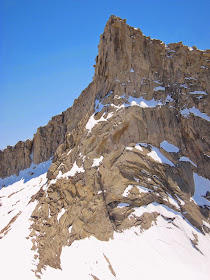
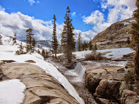
 |
| Winter Sunset from the Tablelands. |
A few weeks before this trip my wife and I went to the first BPL Southern California GGG. The good people at BPL (Backpackinglight.com) have been holding an annual GGG (Gathering of the Gear Geeks) in Northern California for many years, but this was the first 'gathering' in Southern California. We weren't exactly sure what to expect.
Fortunately it turned out to be a fun experience. We met many other hikers including Marian, an experienced backpacker from Romania. By the end of the GGG we had agreed to do a snowshoeing trip before the season was over.
A few weeks later it was time to hit the trail. I planned on staying out for a week while Marian would head back after a few days to meet his wife in Sequoia. I had an entire week to explore some of the remote areas of the Tablelands and beyond in the unique beauty of the winter.
We started out with some pleasant forest hiking with just a few patches of snow.
 |
| Tree Moss. |
 |
| Packed and ready for a week in the backcountry. |
 |
| We started at the Wolverton trailhead in Sequoia National Park |
 |
| After a short time we followed the steep 'Hump' trail |
The views really opened up once we made it over the Hump.
 |
| The view looking east from the top of the Hump. |
We camped by Pear Lake the first night. The altitude made for a rough first day.
 |
| Mountain Laurel Designs cuben Solomid. |
The next morning we headed over the ridge toward Winter Alta. We took the route to the right of the Matterhorn.
 |
| Our route went to the right of the Matterhorn (the snow free granite spire on the left) |
A beautiful clear morning on frozen Pear Lake:
 |
| Morning on frozen Pear Lake |
 |
| Morning on frozen Pear Lake. |
Once we reached the base of Winter Alta (on the east side) a storm blew in and we were stuck in a white-out for about 1/2 hour. Soon the snow started and we quickly made camp at one of the lakes just below the north side of the ridge.
 |
| Looking back toward the Matterhorn on the climb to Winter Alta. |
 |
| Approaching storms meant it was time to hunker down by this frozen lake. |
Of course the snow let up once we got our shelters setup, so we melted more water and made some dinner. By 6:30 things opened up and I climbed to a ridge for sunset.
 |
| Melting snow for dinner. |
 |
| Snow camping in the Tablelands. |
 |
| Sunset (shot in "Super Vivid"). |
The next morning we made it over the ridge for this view of Moose Lake. The next storm was already making its way up the canyon.
This is Marian looking north out over Tablelands Meadow below. There was just enough snow that we could keep our snowshoes on while traversing the ridge.
 |
| Tablelands Traverse |
Tablelands Meadow below:
 |
| Tablelands Pano. |
Later the same day we split up and I got stuck in another storm while crossing Pterodactyl Pass. Every few minutes I would get a glimpse at the possible route toward Lonely Lake. Somehow with GPS, topo map and compass I made it to Lonely Lake.
 |
| View East from Pterodactyl Pass during a brief break in the clouds |
This is what the same view looked like a few days later
 |
| View East from Pterodactyl Pass two days later. |
The giant boulder on the lower left (see photo below) provided some protection from the big winds that swirled around the Lonely Lake cirque that night.
 |
| Lonely Lake Camp |
The next day I explored the ridge that surrounds Lonely Lake. I had planned on going over Horn Col and down into Deadman Canyon, but quickly changed plans after seeing the steep snow and avalanche potential at the south end of the canyon. I decided to explore the entire ridge that surrounds Lonely Lake.
 |
| The south end of Deadman Canyon |
 |
| Glacier Ridge and Deadman Canyon 2,000 feet below. |
The north part of the ridge provided some good views down toward Big Bird Lake. .
 |
| Big Bird Lake |
. . and north toward Deadman Canyon.
 |
| The view north toward Deadman Canyon |
I ended the day at the west end of the Lonely Lake cirque.
 |
| Lonely Lake Cirque |
 |
| Lonely Peak (unofficial name) |
 |
| Lonely tree |
 |
| Boulders balancing on a precipitous ledge |
The next morning I headed back over Pterodactyl Pass. This time the weather was clear with good views of the Great Western Divide to the east.
 |
| Great Western Divide Pano from Pterdoactyl Pass |
. . and clear views to the west of Moose Lake and the Tablelands area.
 |
| View west from Pterodactyl Pass |
Before moving on I had to melt some snow for water. This becomes routine throughout the day when hiking in the snow.
 |
| Melting snow at the top of Pterodactyl Pass |
 |
| Trail Designs Sidewinder titanium windscreen |
 |
MSR Windpro stove
|
I continued along the Kings-Kaweah Divide to this amazing frozen lake near the top.
 |
| Frozen lake at the top of the Kings-Kaweah Divide |
 |
| Frozen hiker on the Kings-Kaweah Divide |
Another storm threatened that afternoon so I setup shelter on the north side of the ridge overlooking Ferguson Canyon and the Great Western Divide. Mt. Brewer is the tallest pointed peak in the distance.
 |
| Sheltered from the wind on the north side of the Kings-Kaweah Divide. |
 |
| The view of the peaks on the Great Western Divide from the Kings-Kaweah Divide |
After a long night I set out to check out the granite spires on the ridge that overlooks Box Canyon, but the clouds looked threatening and I didn't want to get caught at high altitude and on a ridge once the weather started. I decided to head down to Tableland Meadows.
 |
| Tablelands Pano |
The snow was melting fast in Tablelands Meadow.
 |
Lower Tablelands Meadow
|
 |
| Lower Tablelands Meadow |
 |
Lower Tablelands Meadow
|
 |
| Pear Lake Ski Hut |
I watched the sunset through the trees on the way back to the Wolverton parking lot and was on the road before dark.
 |
| Sunset through the trees on the hike out. |
For a cool video of this trip check out:
An overview map of my route (click for full size):
And finally. . . for gearheads please check out my:
I used several pieces of custom (aka homemade) winter gear for this trip.
I added a few more ounces of down to my shoulder season quilt which made a huge difference in warmth this winter! For more info on my homemade Winter Quilt check out:
I also started using a slightly heavier backpack for the heavier loads needed in winter. For more info on my homemade Heavyweight Ultralight Backpack check out:
Thanks for reading!


Amazing area and photos! Spring is such a great time to be out there! -David
ReplyDeleteThanks David! Summer is going to be good too:)
Delete