I have been wanting to get an up-close and personal look at the Minarets ever since I rushed by them (much too quickly) while thru-hiking the John Muir Trail a few years ago. Their dark volcanic spires are beautiful and striking against the collection of small alpine lakes at the base of the range.
After spending much of the winter diligently studying Steve Ropers cross country route that traverses the area I was ready to hit the trail. . . or off-trail as much of the route required.
Fortunately a three day window of time opened up on the way back from another trip in the northern Sierra this summer. . . So with permit in hand I was ready to leave from the Devils Postpile trailhead near Mammoth Lakes.
The first river crossing near Devils Postpile National Monument:

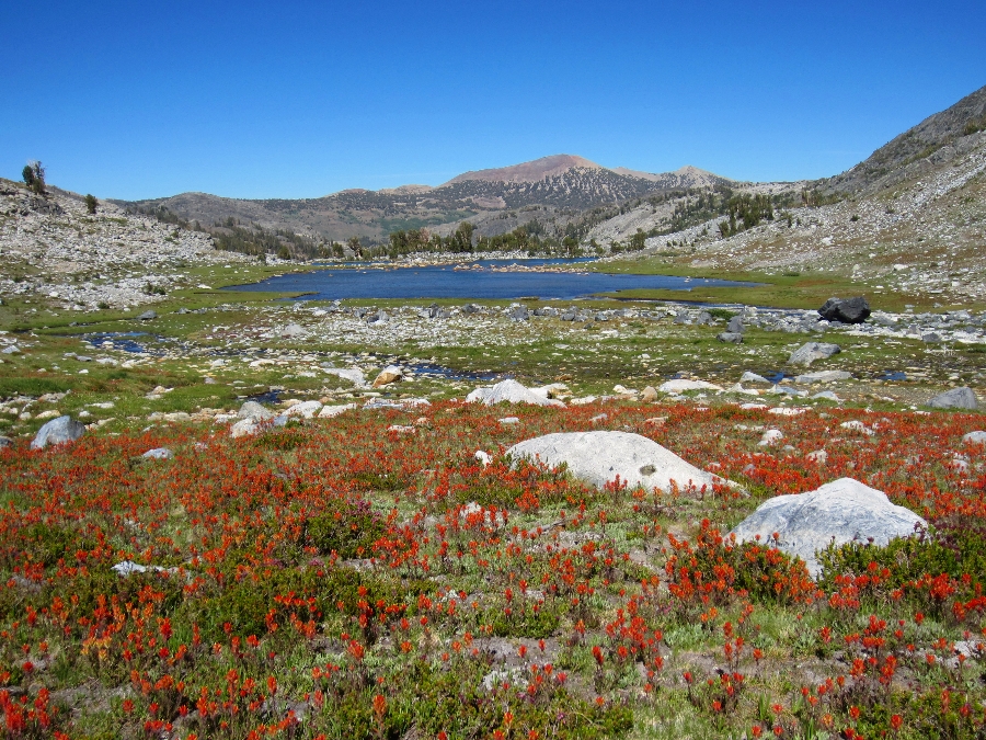
After climbing the 2,000 feet of switchbacks out of the valley I came across a huge stand of wilderflowers. Although it was a low snow year the creeks were still flowing which kept things colorful:

Soon I was leaving the trail at Superior Lake and heading up toward the first cross country pass. This is the view back on the climb up to Nancy Pass:

Unlike most of the backcountry there were no ducks on the route up to Nancy Pass. I was a little concerned that maybe I was going the wrong way, but finally I found some use trails at the top. This is the view of Nancy Pass on the climb up from Superior Lake:

The first close up view of Minarets (to the north) from the top of Nancy Pass:

The cross country route to the Minarets included some boulder fields:
 |
. . . and snowfields: |
 |
This is looking back at the north side of Nancy Pass:
|
 |
The next section was mostly easy walking through meadows:
|
 |
. . . a Deer on the south shore of Minaret Lake: |
 |
| Looking back at Minaret Lake on the way up to Cecile Lake: |
 |

Roper describes the route from Minaret Lake to Cecile Lake via a Class III notch at the right side of the wall at the end of the small canyon. I ended up taking an alternate route up the north side of the small canyon. The use trail that leads from Minaret Lake up toward Cecile Lake actually climbs the north side of the canyon via some obvious switchbacks at about the midpoint between Minaret Lake and Cecile Lake. Once at the top there are several use trails that lead west through a small cirque (with a tarn) then over a small ridge to the eastern shoreline of Cecile Lake. This route appeared to be well used and much easier than the Class III notch.
Here is a detailed map of the alternate route (click for full size):

By late afternoon I found a small camp on the east shore of Cecile Lake with Volcanic Ridge in the background:
 |
Soon the sun was setting behind the Minarets: |
 |
The next morning I woke to some amazing colors at sunrise: |
 |
Sunrise on the Minarets: |

Sunrise on Riegelhuth Minaret:

The Minarets and a unique perspective of Mt. Ritter and Banner Peak in the background:

The Minarets from Cecile Lake. Clyde Minaret is the tallest and in the center from this vantage point. (Click for full size pano):

After arriving at the outlet of Cecile Lake I followed a steep use trail down the talus toward Iceberg Lake. The use trail follows along the east side of the waterfall leading between the two lakes:

The Minarets from Iceberg Lake:

The outlet of Iceberg Lake is amazing!

This pano is far from perfect, but it gives a basic view of the route from Cecile Lake down to Iceberg Lake (click for full size):

After following the outlet stream from Iceberg Lake for about 125 yards I crossed and followed the obvious use trail on the west side. This leads to the meadows above Ediza Lake:

From these meadows I followed the creek up toward the base of Mt. Ritter and Banner Peak. This area was classic summer Sierra with crystal clear waterfalls, puffy green grass, wildflowers and granite.

 |
 |

Roper calls this the 'bleak tarn' at the base of Ritter and Banner:

My next destination was Nydiver Lakes, just to the north:
 |
The first view of Whitebark Pass (the south side is easy): |
 |
Once over Whitebark Pass the first view of Garnet Lake: |
 |
| Add caption |
The north side of Whitebark Pass is another story. Roper recommends staying to the right (east) side of the snowfield and descending via a very loose and very steep talus slope (the red line on the left in the photo). I decided to head over to the left (west), cross a small portion of the very steep snowfield then take the granite benches down to the bottom (the red line on the right in the photo).
For more details on the alternate route over Whitebark Pass check out: White Bark Pass Alternate Route.

The meadow between Garnet Lake and 1,000 Island Lake was beautiful!
The walk through the meadow and over the small ridge to 1,000 Island Lake is an easy stroll. There is even a well used trail along the shore of 1,000 Island Lake towards the cutoff to North Glacier Pass:

The route up to North Glacier Pass was idyllic Sierra with spring time wildflowers blooming, crystal clear waterfalls draining directly from the snowfields above and great views of Banner Peak:

I was loosing light quickly by the time I reached the upper plateau with the pass in sight. I was traveling light and figured I would just camp wherever and whenever it got dark:

Fortunately I made it through the lengthy boulder fields and over the pass with plenty of time to find a flat camp on the shore of Lake Catherine. There are three of four flat spots just large enough for a small tent on the northwest shore of Lake Catherine. I didn't have time to explore the rest of the lake. In the background is the back side of Mt. Ritter and the snowfield that leads to the saddle between Ritter and Banner:

 |
| Morning on Lake Catherine (click for full size) |
The next morning I backtracked via North Glacier Pass to 1,000 Island Lake and to familiar views of Banner Peak:


My favorite sandy beach along 1,000 Island Lake:

From 1,000 Island Lake I took the PCT/High Route on the opposite side of the valley to Agnew Meadows. Along the way there were very good views of the entire Minaret and Ritter Range. I had started on the far left two days earlier and camped behind Banner Peak on the far right the night before. Shadow Lake is in the center:

Here is a map of my route (click for full size):

This was a fun trip through some amazing classic Sierra scenery. Hiking through the meadows of blooming wildflowers added a very special element to the trip. The smell of wildflowers was everywhere along the way. . .
About my gear: I was carrying a light load as this was a quick solo trip to get a feel for some of the route that I plan on covering later this summer with a small group. My total pack weight on the first day was about 15 pounds which included food for three days and two liters of Gatorade. Although I don't usually carry a tent I used a Hexamid Solo Tent (8 ozs) to keep the bugs away at night. . . and I'm glad I did!
Thanks for reading.
For a cool video of this trip check out:
Beautiful trip report Andy!!
ReplyDeleteThanks John!
Deleteplease see this link if you haven't already. Matt Greene was hiking in the area July 17 and is missing http://www.supertopo.com/climbing/thread.php?topic_id=2195321&tn=2100#msg2237315 You or your photos may be of some help?
ReplyDeleteHi Anonymous. Thanks for your comment. I have been following the search for Matt on highsierratopix.com. Maverick, one of the moderators at HST, did an extensive search of the area and he posted details online. I didn't see anything while I was out there. I sincerely hope that he is found. Thanks again, Andy.
DeleteGlad you posted this. I was going to since I just read about this trip report on the Matt Greene website. Hope he contacts them.
ReplyDeleteHelga
Hello Helga. I have been following the search on highsierratopix.com. I didn't see anything while I was there. I sincerely hope that he is found. Thanks, Andy.
DeleteHi to all, about 30 years ago i hiked through the minerets. It was a beautiful hike but i need to tell you it was in August with snow everywhere. The person i hiked with got really angry that i could not jump over a crevas that was two feet wide, snow on both sides. I looked down the crevace and could not see the bottom. My legs were intently shaking from the strenuous hike therefore i could not jump over. Because of this we had to go all the way around the minarets, i will never forget those black mountain peaks but we finally made it. He got snowblind and could not see. About 5 mins. after arriving to where we would camp, i found a pair of Ray Ban sunglasses, he became a normal person again and got over i could not jump the crevas and had to go an hour and a half out of the way. No matter how experienced a mountaineer, the terrains around this area is very dangerous to me. Im asking my Lord and Saviour Jesus Christ to guide a special person to find Matthew Greene. I know if i had to try to jump that day, i would not be here today. God Bless this whole family. Hope he is surviving out there somewhere just living off the land.
ReplyDeleteAndy, Thanks fo rthis great report. I am planning to be up in that area soon. I had a question about your class II route from Minaret to Cecile.... I had heard there is a clear use trail that leads to the class III notch. Did your route start on this same use trail and then you diverged, or was it an entirely separate use trail that you started on form Minaret lake? - Thanks, David S
ReplyDeleteThanks David. I followed the well defined use trail from Minaret Lake up toward Cecile Lake. I intended to follow that use trail to the Class III route but somehow I got sidetracked and followed a separate trail up the north side of the canyon. I think there was a place where I had to decide between two options. The trail that I took led right up to an easy 'pass' at the top. From there it was an easy stroll past a small tarn and over a small hump to the rocky shoreline of Cecile Lake. There were several use trails along this last section. I hope that helps
DeleteYes, Thanks. I will let you know if I find your route, if not, I will do the Roper route. By the way, I really enjoyed your youtube. Very beautiful, informative and pretty darn funny too. - David S
Delete