Sierra High Route & Mono Divide: 06/26 - 07/02/2013
Pinecreek Trailhead.
This trip was originally planned to be an 11 day SHR section hike from Merriam Lake to the Silver Divide and back via the PCT. I had planned a few layover days to enjoy Lower Mills Creek Lake and Bear Lakes Basin. . . but by the time I finished a few last minute gear projects (a new backpack, sleeping quilt and stove) the plan was compressed into an 8 day loop with no 'zero' days.
So with a new more comfortable internal frame backpack and 8 days of food I headed up the switchbacks from the Pine Creek trailhead. The first 2,000 feet to Lower Pine Lake made for a steady but reasonable climb. I enjoyed a nice breeze and long lunch break along the outlet creek.
For the rest of the day the bugs chased me through Granite Park.
Overview map of the Mono Divide & Sierra High Route Loop.
Muggy bug heaven on the first day in Granite Park.
After 3,500 vertical feet I was ready to camp by 7:00 pm. There were good places to camp along the creek in upper Granite Park. I cleaned up, had dinner and found refuge from the bugs in my Zpacks Hexamid solo tent.
Camp in upper Granite Park.
A typical classic Sierra scene in Granite Park.
The second day I started up toward Italy Pass:
Looking back toward Mt. Humphreys the next morning on the way to Italy Pass.
Italy Pass is the low point in the center.
Beautiful waterfalls and puffy grass meadows on the way to Italy Pass.
Once I made it over Italy Pass the cross country route to Lake Italy was an easy scramble. There was still some snow along the north shoreline of Lake Italy. A few hikers had just crossed and left easy steps for me:
Crossing the snowfields on Lake Italy.
I joined the Sierra High Route at Lake Italy and followed the north shoreline to Toe Lake:
Lake Italy.
I made camp at this small tarn at about 11,000 feet. Just over the edge of this tarn was a 1,000 foot drop off down to Lake Italy where I had been early that day.
The next morning I headed up to Gabbot Pass. Granite benches provided an easy cross country route to the pass.
Gabbot Pass is the low point in the center.
Looking back at my camp from the night before. To get some perspective of the immense size of this area you can see where I camped on the opposite shore of the little tarn toward the bottom. Bear Creek Spire and Mt. Julius Ceaser are in the background.
I was concerned about crossing the snowfields on the north side of Gabbot Pass. Fortunately the snow was set which made for easy walking down the pass:
The snowfields on the north side of Gabbot Pass.
The view north from Gabbot Pass. Ritter and Banner are the dark peaks visible in the distance.
Along the way down the north side of the pass I passed a tarn that was fed by the melting snowfields:
Snowfields melting into a tarn.
These puffy clouds would bring some serious storms later in the day.
Before long I was on the ridge overlooking Upper Mills Creek Lake. The High Route follows a ridge just to the right (out of the picture).
Upper Mills Creek Lake.
Unfortunately the storm hit while I was crossing the boulder fields that lead down to Lower Mills Creek Lake. I couldn't continue scrambling down the large slick granite boulders in the rain so I backtracked and spent three hours taking cover in a granite cave. It wasn't safe to continue down the boulder field in the rain so I just watched the hail and listened to the sound of the thunder crashing against the walls of the cirque.
According to Steve Ropers guide there are no actual caves in granite. The granite cave-like shelter where I stayed was actually a sheltered overhang created by large boulders. After about an hour under the rock shelter I noticed huge waterfalls located 2,000 feet above me in the granite cliffs located across the valley. These waterfalls were draining the huge cirques even higher above. I watched as the waterfalls filled more waterfalls below on the way to the river below me. The sound of these waterfalls and the now roaring river below was awesome.
During a break in the storm I found a place to dry out and camp along the shore of Upper Mills Creek Lake. Just after I finished setting up my shelter the sky opened up again. I had dinner in the tent and finally fell asleep to the sound of the waterfalls nearby. The Zpacks Hexamid Solo Tent I was using held up to the high winds and I stayed dry and comfortable the whole night.
The next storm was coming. My camp along the shore of Upper Mills Creek Lake. Mt. Gabb in the background.
The next morning everything was clean and beautiful from the rain the previous night. I made my way down the boulder-field to Lower Mills Creek Lake.
Morning on Lower Mills Creek Lake.
Steve Roper calls the area just below Lower Mills Creek Lake 'classic Sierra'. This place was an amazing mixture of sandy beaches, green meadows, wildflowers, granite benches and crystal clear water leading from one beautiful pond to the next.
"Classic Sierra"
"Classic Sierra"
After wondering along this magical place it was time to descend to the Second Recess. The cross country route in this area included some bushwhacking through unpleasant dense forest and brush. . . and the bugs were out in force! Eventually a faint use trail became visible down to the floor of the Second Recess.
The view across the Second Recess on the cross country route through the forest.
The creeks, flowers and open forest in the Second Recess were beautiful, and completely void of any other people. This area is somewhat remote and it takes at least a day to reach from either side of the Sierra.
Crystal clear creek in the Second Recess valley.
What??? This water was so clear and beautiful I just had to take a quick swim.
Soon I met a maintained trail and followed it the rest of the way down to Mono Creek. Traveling on a trail was much easier than any of the cross country travel that I been doing. I got up to about 4 mph while cruising downhill until I realized that I had run out of water. . . just as I hit some switchbacks that I hadn't noticed on the map. I couldn't believe I had missed filling up on water while hiking along the creek! I finished the last few drops of water left in my bottles and set a slow pace toward the next water source.
Before long I could hear the waterfalls of the North Fork Mono Creek. It's strange how even though I had been completely parched and felt like I had a mouth full of sand moments before, I didn't feel like stopping to get water once I made it to the river. This didn't last for long.
The JMT follows along this portion of Mono Creek. It was only 10 minutes before I was sharing the trail with PCT or JMT hikers heading the opposite direction. Most looked like they had just resupplied at VVR (on the opposite side of Edison Lake). I recognized the extremely focused nature of the solo hikers who seemed to be pounding out the miles in the cooler late afternoon temperatures.
While thru-hiking the JMT two years earlier I camped on the south side of Mono Creek just before the switchbacks up Bear Ridge. By the time I reached the same place I didn't feel like making the climb over the ridge so I scouted a great spot to camp above the creek on the south side. This area has several good places to camp but there was nobody around. I found a nice sandy beach area with a large sloping granite area to wash up, do some laundry, have dinner and just chill.
Camping along Mono Creek.
Making dinner just involved boiling water for some tasty lasagna with meat sauce. Every dinner is like gourmet to a hungry hiker after a day in the backcountry.
Making dinner along Mono Creek.
The next day I got an early start up Bear Ridge. The JMT guidebook says to fill up on water at Mono Creek as there is no water until the other side of Bear Ridge. I have found this to be totally false. There are several small creeks at the bottom and a very short use trail to a waterfall about half way to the top. I filled up with water and headed over the ridge.
Lush landscape along the trail to Bear Ridge.
Once over Bear Ridge the trail drops down and follows Bear Creek. I had forgotten how beautiful this area can be. When I was here in late September 2011 and it was just another trail, but in June 2013 it was a lush forest with a high flowing creek.
Trail along Bear Creek.
Waterfalls along Bear Creek.
Lunch spot Bear Creek.
I left the JMT/PCT at the Lake Italy trail junction and started the climb up to the lake. Although the map shows this as a trail some of it is completely missing. The area below was a relaxing section along a meadow with many wildflowers. The bugs were waiting for me!
Lake Italy "trail".
The late afternoon shadows were climbing the sides of the granite peaks as I arrived at the large flat granite area below Lake Italy. I had seen photos of this area and was looking forward to camping here. I watched the alpenglow on the ridges above Teddy Bear and Brown Bear lakes. My plan was to hike to these lakes the next day, cross White Bear Pass and explore Bear Lakes Basin. . . .
Camping along the outlet creek below Lake Italy.
. . . but the combination of my lack of conditioning and acclimatization (typical of my first Sierra trip of the season) and the constant hoards of mosquitoes finally caught up to me. I decided to just take it easy the next day and try to enjoy the area.
Usually I leave the Sierras wanting to stay longer. I start thinking of ways to convince Candy that we should move to Bishop so I (we) could spend more time in the mountains. There are so many amazing places to explore and not enough time.
But by this point in the trip I just wanted to get out. Anywhere without the persistent swarms of mosquitoes. It felt like there was nowhere to hide. I spent most of the day in the refuge of my tent, only coming out to quickly get water or food. Even though I was using toxic amounts of DEET, a headnet and long sleeve windshirt it was difficult to relax. I was reminded later of my childhood allergy to mosquitoes.
By the end of the day I felt better and got a good nights sleep. The next morning I felt rejuvenated and ready to tackle White Bear Pass.
Alpenglow on White Bear Pass. The pass is the low spot at the center of the ridge. Although it looks like there is a huge impassable vertical wall blocking the way it actually turned out to be a reasonable scramble to the top.
The next day I followed the granite benches along Teddy Bear and Brown Bear Lakes toward White Bear Pass.
White Bear Pass from Teddy Bear Lake. Is that a vertical cliff at the top?
Brown Bear Lake.
From the distance White Bear Pass looked like it was blocked by an impassable vertical cliff, but like most Sierra passes it turned out to be easily manageable. There were even a few grassy meadow-like areas toward the top.
Almost to the top of White Bear Pass.
By the time I reached the top of the pass the afternoon storms were approaching.
The view north from White Bear Pass. Teddy Bear and Brown Bear Lakes are below.
There were still a few small snowfields at the top of the pass.
The top of White Bear Pass.
Although most of the lakes in Bear Lakes Basin are surrounded by boulders, I found a small grassy meadow with a creek and wildflowers leading down into White Bear Lake.
White Bear Lake.
Once over the pass the views into Bear Lakes Basin were beautiful.
The view south from White Bear Pass. In the background from left to right: Granite Bear Pass, Peak 12,918, Feather Peak, Feather Pass.
Black Bear Lake and Feather Peak.
I met another solo hiker who had just crossed Feather Pass. The photo below shows the north side of the pass from Bear Lakes Basin. He said it was an easy scramble over the pass.
Feather Pass.
New life in Bear Lakes Basin.
Big fat Marmot.
After waiting out the afternoon storm in my shelter I decided to head out a day early. It was 3:00 which I figured left enough time to make it out through Granite Park and to the Pine Creek trailhead before dark.
The view west from Dancing Bear Pass. Gemini and Seven Gables in the background.
There was only a small snowfield and little tarn at the top of Dancing Bear Pass.
Dancing Bear Pass.
Tarn at the top of Dancing Bear Pass.
I contoured from Dancing Bear Pass to Italy Pass. Along the way I crossed a few snowfields.
Crossing snowfields on the way to Italy Pass.
The snowfields were getting soft by later afternoon. At one point I fell through the snow and got wedged between some boulders below.
Looking back toward Dancing Bear Pass on the way to Italy Pass. Another storm was approaching but didn't bring much rain.
The view north from Italy Pass.
I made it to Italy Pass and started the descent through Granite Park.
The view south from Italy Pass. Mt. Humphreys is the large peak in the center background.
Granite Park.
Lush meadows in Granite Park.
Granite Park.
By the time I made it to Honeymoon Lake the shadows were getting long. I hiked the final 2,000 feet down to the Pine Creek trailhead by headlamp in the dark. It was all worth it for the cheeseburger and shower in Bishop!
Sunset over Honeymoon Lake.
It had been a long time since my last trip into the High Sierra in early season. Although June brought meadows full of beautiful wildflowers it also came with afternoon storms and swarms of mosquitoes. Would I do it again? Absolutely!
Check out a cool video of this section of the Sierra High Route!
Some thoughts on gear:
The Zpacks Hexamid solo tent worked well. The netting kept all bugs away. It performed well in heavy winds during thunderstorms. I stayed dry even when the rain was coming towards the front of the tent by using my goundsheet/poncho/pack cover to cover the side of my quilt.
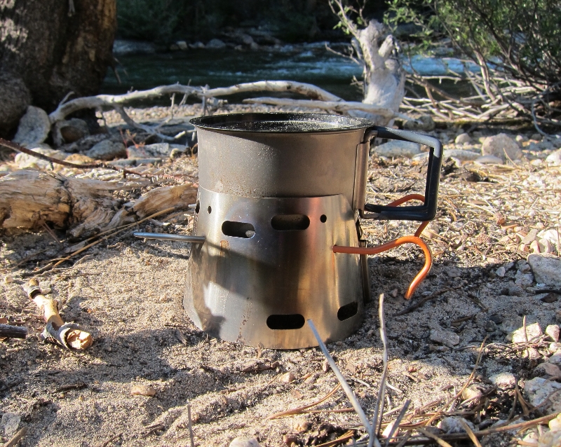
The new stove system I was using was much smaller than the usual Caldera Keg system I have used in the past. The new titanium windscreen/pot holder made boiling water a breeze but I had to use titanium stakes to hold the cup. Next time I will try using the 'beer bands' offered by Traildesigns to hold the cup so I don't have to go digging for tent stakes (after they have already been used to set up my shelter).
I was also using a new homemade backpack. The larger/wider hipbelt was much more comfortable with the heavy load (8 days of food in a bear canister).
The new quilt was more than warm enough. It is conservatively rated at 30 degrees but I think it's more like a 25 degree quilt. Check out the details of the New Ultimate Quilt!
Stay tuned, I will be posting more info about my latest homemade/custom gear.
Thank you Bill! It would be nice if a labor of love turned out to be something book-worthy. I will be in one of your favorite areas next week. More photos to follow.


Hi Andy,
ReplyDeleteI'm waiting for the photos to load.
Your dedication to the Sierras is wonderful; and your stamina --whoa!!
Seems to me that a book of your travels, photos & camping advice might be worth exploring.
Bill
Thank you Bill! It would be nice if a labor of love turned out to be something book-worthy. I will be in one of your favorite areas next week. More photos to follow.
Delete