Blackcap Basin - Lake Confusion Pass - Goddard Canyon - Ionian Basin - Finger Col
 |
| Storm clouds rolling in above Rainbow Lake |
Over the past twenty years my brother Jeff has organized annual backpacking trips in the Sierras for our varied group of lifetime friends. Even as the group has scattered around California and beyond he has found beautiful places for us to meet. A few years ago he scouted out a cross-country route to a secret spot he discovered in the Sierras. . . but the rugged terrain and desire for some dude time meant it was a guys-only trip.
I will never forget struggling down loose granite slopes in my old boots to this new Sierra destination. As I ran out of water, carried way too much gear and even forgot to bring enough food I realized it was time to rethink my backpacking strategy. Although it was a challenging trip (I ended up loosing several toe nails) that time in the back-country reignited my enthusiasm for exploring the High Sierra. The guys spent most days lounging by the granite pools and waterfalls but I went wandering up the river, always wondering what was beyond the next ridge.
Fast forward a few years and I was ready to take my own cross country trip far up that same river. . . and beyond.
This trip was originally planned to be a ten day journey on the Sierra High Route but a last minute family emergency meant I had to reschedule for late September and into October. At that time of year, the shoulder season, the forecast called for snowstorms in the middle of the trip. I brought an extra warm 20 degree quilt, rain and snow gear and a winter shelter. (See
Shoulder Season Gear List).
I entered the Sierra from the west via the Maxson Meadows trailhead near Courtwright Reservoir. It was late afternoon by the time I arrived and with only a few hours of daylight left I decided to set out cross country towards the North Fork Kings River. By 7:00 pm it was already too dark to continue so I found the nearest level spot and slept under the stars.
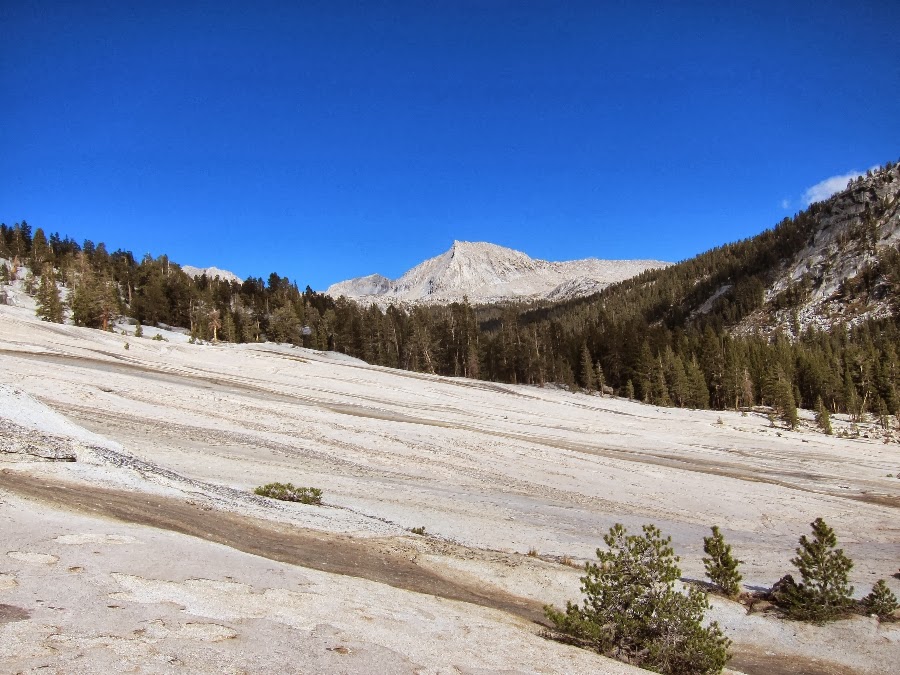
The next morning was warm and clear and I got an early start up the granite slabs along the North Fork Kings River toward the Blackcap Basin Trail. Instead of taking the mostly forested Blackcap Basin Trail ten miles to where it meets the North Fork Kings River I decided to take a six mile cross country route along the river. From the USGS topo maps and photos on Google Earth it looked like there was a clear route all the way along the river to the where it meets the Blackcap Basin Trail. . . except for one place where the canyon narrows with steep granite walls on either side.
Secor's guidebook warns that this cross country route, "is for experienced cross-country hikers only" and I figured after completing much of the Sierra High Route I would be fine. The first part of the morning hike was fun, just basic boulder scrambling and hiking along the smooth granite sidewalks. . .
 |
| Camping on the North Fork Kings River |
 |
| Cross country travel on the North Fork Kings River |
 |
| Cross country terrain on the North Fork Kings River (click for full size) |
After a short time the canyon started to narrow. Since the water level was low this time of year it was possible to just hop from boulder to boulder in the middle of the river bed. . . but eventually the canyon became very narrow and it cliffed out on either side. I could either swim across or try to climb along the sides. The left side was vertical and there was no way around without technical climbing gear.
Fortunately the right side looked better. After studying the various cracks on the wall it looked like there might be a route up and over the right side. I was excited to keep going and relieved that I wouldn't have to go back down the canyon to search for another route.
 |
| North Fork Kings River |
 |
| Boulders and granite walls |
 |
| Eventually the river cliffs out on both sides. |
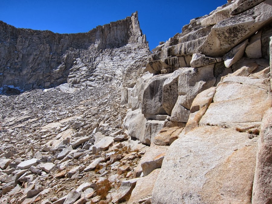
I spent a long time studying the cracks on the canyon wall, trying to find a safe route to the top. Even though it looked easy the wall quickly got very steep the higher I got. After trying several different cracks I finally found what looked like a route up the middle of the right wall. A small tree branch was growing out of a crack along the way and since it looked like it had been used as a foothold before I figured I was on the right track.
I couldn't tell from below but once I got about two thirds of the way up I found a section where the footholds disappeared. I was able to reach the next hand hold with my right hand but I would need to let go of my left hand and foot to reach the next foothold. . . and I wasn't sure if that next foothold was solid. I looked down to check the exposure before taking such a risky move and I was surprised how far I had come and how steep the wall had become. After a few steep ledges the wall finally reached the river about twenty five feet below.
I weighed my options. If I could just make it past this section I would be home free. There was a clear route along the wall just past the next crack. Climbing back down didn't look safe so after getting a good grip on the right handhold I reached for the foothold with my right foot.
Unfortunately the right foothold gave way and I instantly found myself hanging from my right hand. I couldn't believe my stupidity. I looked down again. I actually said, "now I'm hanging from this wall, come on?!?!". I was still wearing my pack with six days of food, about 22 lbs.
I reached for the crack with my left hand but it was at an angle which made it difficult to grip. I tried to pull myself up several times but each time I lost the grip with my left hand. My right hand was getting loose. Eventually I lost the right hand hold and started to fall down the wall.
There was enough time to turn onto my side before sliding over the first ledge. After that I started to really pick up speed. During this longer section before the next ledge I remember thinking that I would probably end up with a broken leg. I slid onto my back before going over the next ledge. This time I managed to land on my left foot. I tried to run straight down the wall but when I started to tumble head first I pulled back and landed on my back before going over the last ledge.
I finally came to a stop on the boulders next to the river. I took a quick breath and checked myself for injuries. With the exception of various cuts, abrasions, bruises and a twisted ankle I was fine. My pack must have provided some padding along the way. I cleaned up, using everything in my first aid kit, and slowly started back down the canyon.
Later I discovered a large cut and abrasion on my left hip, probably the result of going over the first ledge on my side. I used my remaining baby wipes to clean it but I didn't have a bandage large enough to cover it. For the rest of the trip my long johns would stick to the abrasion during the night. My daily routine included separating the the fabric from the abrasion each morning.
 |
| I spent a long time trying many of the possible routes up this wall (click for full size) |
 |
| Unfortunately I took the fast route down. |
 |
| The view from where I finally landed. |
 |
| Just a few scrapes. |
I followed the river downstream and after finding a better route I was leisurely walking along the ridge far above the river. The rest of the way to the junction with the Blackcap Basin Trail was a mix of easy granite benches and some bushwhacking through dense forest. I hiked through sunset and setup camp in the trees. I usually like to camp above treeline to enjoy the views, but at the lower elevation the trees provided some protection from the storms in the forecast.
 |
| I backtracked and followed this ridge above the river. |
 |
| North Fork Kings River |
 |
| Cross country along the North Fork Kings River (click for full size) |
 |
| Bushwhacking through the forest. |
 |
| Ready for the storm that never arrived |
The next morning I headed up the Blackcap Basin Trail. At 9,600 feet I set out cross country up the granite slopes toward Rainbow Lake. The views of the White Divide and Finger Peak gradually opened up to the east.
 |
| Granite sidewalk made for easy cross country travel |
 |
| The view of the White Divide |
 |
The White Divide and Finger Peak
|
I reached the sandy shoreline of Rainbow Lake and by sunset I was ready for a cold night at 11,000 feet. I could see the storm clouds filling Blackcap Basin below. Eventually the clouds rolled right over my camp and it got COLD. . . 23 degrees that night. In the morning my shelter was covered in frost, which made it look like an igloo.
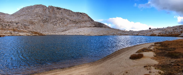 |
| Sandy beach along the shore of Rainbow Lake |
 |
| Alpenglow over Rainbow Lake |
 |
| Storm clouds rolling in at night |
After waiting for my gear to dry I headed toward Lake Confusion Pass, just above my camp. The view from Lake Confusion was stunning. There is a large 900 foot drop-off on the opposite side of the lake down to Goddard Canyon. Emerald Peak, Peter Peak, Mt. McGee and Mt. Goddard were all visible across the other side of the lake.
 |
| Drying out gear in the morning |
 |
| Looking back to Rainbow Lake on the way to Lake Confusion |
 |
| The first view of Lake Confusion with Mt. McGee and Mt. Goddard across the canyon |
 |
| Lake Confusion |
 |
| Lake Confusion |
 |
| Martha Lake and Mt. Goddard from Lake Confusion Pass |
 |
| Goddard Canyon from Lake Confusion Pass |
Lake Confusion Pass is described as Class II by Secor and according to his directions the route follows a very steep granite wall. I read about a alternate route on
High Sierra Topix that follows a bench on the ridge then leads to an easy use trail and switchbacks to the Goddard Canyon below.
 |
| Steep wall down to Goddard Canyon via Secor's Lake Confusion Pass. . . ouch. |
 |
| . . . or the alternative, a meadow along the ridge. |
By the time I reached the entry to Ionian Basin via Goddard Pass the storm clouds were gathering across the canyon. It was getting colder in the high elevation and the waterfalls were mostly frozen along the way. I was taking note of all the possible places to make camp in case I needed to hunker down along the way. By the time I reached Ionian Basin I could see the storm clouds starting to drop snow right behind me. Soon the snow and high winds arrived. I backtracked through the blowing snow to a small level spot just below a ledge on the shore of lake 12,280 at the base of Mt. Goddard. This lake was completely bound by boulders except for one small level spot which was just large enough for my shelter.
After getting settled in I tried to go outside to make dinner but the wind created a chill that was freezing my fingers. I only brought glove liners and a pair of Zpacks waterproof/breathable cuben rain mitts. I was wishing I had brought some down mitts.
I ended up waiting out the storm for 16 hours in my
MLD cuben Solomid. I was concerned about being able to get around in the snow the next day but fortunately most of the snow had melted by the afternoon.
 |
| Looking back at the storm clouds gathering above Martha Lake |
 |
| Frozen waterfalls, now that's cold. |
 |
| Scrambling over Goddard Pass |
 |
| Lake 11,951, Charybdis and Scylla in the background |
 |
| After the snowstorm at 12,280 feet |
 |
| The next morning, camping below Mt. Goddard. |
 |
| A rare flat camp site |
By morning the skies were clear and the sun had transformed the area. The rest of the trip was warm and beautiful. I spent a few hours wandering through the Ionian Basin, sometimes following faint use trails and even a few cairns. I had planned on camping below Scylla the night before but the long storm meant I had to cut things short and keep moving. I passed lake 11,951, Lake 11,818 and the famous pink and purple rocks on the way to Lake 10,232 in Goddard Canyon.
 |
| Lake 11,951 |
 |
| Lake 11,818, Scylla in the backgound |
 |
| Land bridge over Lake 11,818 |
 |
| Finger Peak from Lake 11,818. |
 |
| Alpine reflection |
 |
| Waves of rock |
 |
| 1,600 foot drop off to Goddard Canyon just beyond waves of rock |
I followed the various benches and granite slabs down from the outlet of Lake 11,818 toward Goddard Canyon and Lake 10,232 below. There were a few good areas large enough for several people to easily camp.
 |
| One of the many benches on the way to Lake 10,232 |
 |
Lake 10,232, the headwaters of Goddard Creek
|
 |
| The headwaters of Goddard Creek. |
 |
| Lake 10,232 |
 |
| Ancient |
I stopped for dinner at Lake 10,232. This part of the canyon mainly faces north/south so the sun started to disappear earlier than I had expected. I made my way to the entry of Finger Peak Basin and chased the setting sun to a comfortable spot facing Finger Peak. I slept on some pine duff under the stars. This ended up being the most comfortable spot I've slept in a long time.
 |
| Dinner at sunset on Lake 10,232 |
The next morning I woke to a beautiful view of the sunrise on Finger Peak. My first goal of the day was to cross Finger Col. The cross country travel in the basin was straightforward and before long I was at the base of Finger Col. . . or at least what I hoped was Finger Col.
 |
| Early morning on Finger Peak |
 |
| Finger Peak basin, Blue Canyon Peak |
 |
| Finger Peak basin |
 |
| Blue Canyon Peak and Finger Peak |
 |
| The route up to Finger Col |
This was my first time over Finger Col so I wasn't exactly sure where it was. The actual 'finger' is on the other side so without a clear landmark I just aimed for what seemed to be the best spot.
I realized that if I couldn't find the way over I would have to backtrack two days and over two more passes to get back. It felt strange to be in such a remote area and completely reliant on information available in guide books and online at
highsierratopix.com. I am always grateful for the people who generously share their experience in the High Sierra. Maybe this will help someone else considering the route.
 |
| Finger Col from the east |
 |
| Finger Peak |
 |
| Finger Peak |
 |
| Headwall on route to Finger Col |
As I got closer to the mostly vertical wall I started to see a few cairns leading the way to the col. There was a steep drop-off along a very narrow cliff band but the route was Class II the whole way. The views from the top were amazing.
 |
| Class II route to Finger Col? |
 |
| A small cairn leading the way to Finger Col |
 |
| View east from Finger Col, all the way to the Palisades. |
 |
| View west from Finger Col, Cathedral Lake and the rest of Blackcap Basin |
 |
| The Finger |
 |
| Vertical wall on the west side of Finger Col |
 |
| View west from Finger Col (click for full size). Cathedral Lake and Midway Lake are below. |
The route down the west side of Finger Col started with a steep and loose scree field that soon leveled out slightly to a long boulder field and eventually to Cathedral Lake.
 |
| West side approach to Finger Col |
 |
| West side approach to Finger Col |
 |
| West side of Finger Col |
 |
| Route down the west side of Finger Col |
 |
| Cathedral Lake |
 |
| Cathedral Lake |
Secor recommends following the south side of the creek from Midway Lake to Portal Lake. After scrambling most of the way down I found that the south side ended at the top of a cliff. I found three places where I might have been able to make it down but after my accident a few days earlier I wasn't going to take any chances. I ended up traversing the entire boulder field, crawling between the boulders and frozen waterfalls in the creek. After an hour I finally found a large cairn along a well used route on the NORTH side. For anybody heading this way take the route on the north side of the creek!
 |
| Portal Lake |
 |
| Secor's route cliffs out on the right/south side. I took the well worn route on the left/north side. |
 |
| Meadow below Portal Lake |
I descended into the trees along the Blackcap Basin Trail. As the sun set in the forest I made it to a large opening where the shallow waterfalls washed along granite slabs and into emerald pools. For my last night I cowboy camped at the edge of the forest overlooking the North Fork Kings River. . .
. . . and woke to clear skies and crystal clear pools in the morning.
 |
| Morning on the North Fork Kings River |
On the way out I stopped to explore the old cabins in Big Maxson Meadow.
 |
| Big Maxson Meadow |
 |
| Original cabin in Big Maxson Meadow |
 |
| In need of a new roof? |
 |
| Dusty bottles and debris |
 |
Cable bridge to gagging station
|
 |
| Meadow Brook Cabin with solar gagging equipment |
The trail follows the North Fork Kings River for about eight miles before it ascends toward Post Corral Meadows. The next ten miles meander through mostly mundane densely forested areas with a few beautiful meadows.
 |
| On the way to Post Corral Meadows |
A rickety wood boardwalk led the way through the last forested section to the trailhead. After hiking along a winding dirt road for another mile I finally made it to the car just before the sun set behind the trees. The finish of another adventure.
 |
| Boardwalk over Maxson Meadows |
Here's an overview map of the route:
 |
| Route map (click for full size) |
Some thoughts about the UL gear used on the trip:
Before leaving on this trip I was continually checking the national weather service (noaa.gov) for the latest forecast. After checking with the local ranger it was clear that a snow storm would be hitting the area right in the middle the trip. Although I was focused on traveling light and fast I was sure to bring all of the gear necessary to stay warm, dry and safe.
The
Mountain Laurel Designs cuben Solomid performed well during the 16 hours I had to hunker down during the storm. The only drawback was that snow blew in through the vent at the top. This was only because I had removed the velcro that is supposed to seal the vent to save weight. That was definitely a case of what Andrew Skurka would call
Stupid Light. Other than that it was great. The small footprint made it possible to setup in a very small space, which was critical because there was only one small place to setup during the storm.
I have started using the
Zpacks waterproof/breathable rain mitts. They kept my hands dry and provided more warmth than I expected. The only other insulation I brought was a pair of lightweight glove liners and together they were enough, except the one night during the snow storm when some down mitts would have been nice.
The only jacket I brought this time was a
Dri Ducks rain jacket and left the
Patagonia Houdini windshirt at home. At 5 ozs for size large this is my favorite lightweight waterproof/breathable jacket. Unlike my
North Face Triumph Anorak it actually breathes well and is reasonably priced at $20 for the jacket and pants.
For cooking I brought the
Evernew 400 ml cup and Sidewinder Ti-Tri with a
BGET (Brian Green Esbit Tray) stove. The whole setup weighs 2.5 ozs which includes the Evernew 400ml titanium mug/cook pot, Trail Designs Sidewinder titanium windscreen/pot holder, a
Ruta Locura carbon fiber lid, BGET esbit stove, a mini Bic lighter and homemade cuben fiber stuff sack. This is the lightest, most packable (smallest), easy to use and convenient setup I have found. It is especially good for someone who just wants to boil a few cups of water each day. It also uses the lightest fuel available. I only use about 7 grams (1/4 oz) of fuel per day, which is nice!
I was using a new internal frame backpack that I designed for this trip. It was made for carrying heavy loads through cross country terrain. For more see the:
Heavyweight Ultralight Backpack.
I brought an updated quilt that I made specifically for the colder Shoulder Season temperatures. For more see the
Winter Quilt with a Custom Trapezoidal Baffled Footbox.


Hi Andy,
ReplyDeleteIt's taking forever to load the pictures, so I'll have to come back tomorrow. Looks like a spectacular trip!!
Thanks for taking the extra time to download the photos. I think you will enjoy it. I'm looking forward to hearing what you think about the Ionian Basin. I still haven't forgotten about Triple Divide Peak. I hoping to get out there next summer.
DeleteAwesome write up and photos! Makes me want to spend more time in that area. -Lunchbox
ReplyDeleteThanks Dave!
DeleteWish I had the knees to join you.
ReplyDeleteThanks for checking in Craig!
Delete