 |
| Morning in Kaweah Basin |
XSL 2015 ~ Cross Country SEKI Loop ~
Nine days of Cross Country travel in Sequoia & Kings Canyon National Park
~ Overview Map ~
 |
| Click for full size map. |
In the spirit of Amy Lauterbach's
Big Seki Loop and Mike White's
Circle of Solitude I decided to create my own loop through the Sequoia & Kings Canyon area. . . but I wanted to stay off existing trails and use cross country routes as much as possible. At times bad weather chased me down to lower elevation but in the end I crossed 7 High Sierra passes over 81 miles.
Days 1-4: Tablelands to Cloud Canyon
After planning all winter I was excited to get into the backcountry. . . but the forecast was for thunderstorms during the first four days! I figured it couldn't be all that bad so I headed into the unknown. I had rain gear, a double wall ultralight tent and even a new custom backpack. I was ready for the worst possible conditions, and at least I could get closer to the high passes than I would if I just stayed home. It seemed like a logical decision at the time. . .
The plan was to leave from the Wolverton trailhead and get to Pear Lake the first night. Although I wanted to the follow
Andrew Skurka's new KCHBR I would skip the route to Silliman Peak and stay at low altitude the first few days. A hiker I met along the way warned of lightning that ignited a tree near Silliman Peak the day before. They watched the helicopters drop water on the fire next morning, fortunately able to stop a potential wild fire.
After the long drive from Laguna Beach I picked up my permit at the busy Lodgepole ranger station. It started raining just as I got back to the car so I waited it out and got hit the trail by 5:00 pm. It was only 6 or 7 miles to Pear Lake and the rain stopped for a few hours while I hiked along the well maintained trail. As I made the turn around the final ridge toward Pear Lake I was treated to a huge double rainbow. . . and then the skies opened up and it rained hard for a few hours.
It was dark by the time I found a decent camp spot, hid my bear canister and set up my tent. I slept like a baby.
 |
| The Wolverton Trailhead |
 |
| Rainy trail. |
 |
| Looking back at the Watchtower Trail. |
 |
| Tokopah Falls below. |
 |
| Double rainbow near Pear Lake. What does it mean?! |
 |
| Camp above Pear Lake. |
The next morning I got an early start and with a heavy pack full of 9 days of food I left the trail at Pear Lake and contoured around the ridge and up into the Tablelands. Most of the rest of the route was cross country. I wouldn't see another person for several days. It's funny but most of the time people don't seem to go where there isn't already a trail. . . which is fine with me since it leaves most of the backcountry in pristine condition with plenty of opportunities for solitude.
As I climbed past Tablelands Meadow and up the granite slabs the weather started to deteriorate. By the time I reached 10,800 feet the skies opened and intermittent drops quickly turned to a constant heavy rain. I put on my poncho and backtracked to the last flat area I had passed. Fortunately I found (what seemed like) a good spot to setup my tent and before long I was inside. Soon I noticed the deluge was filling the nearby tarns and overflowing into the spot where I had setup my tent! After about an hour it let up and I was able to move to higher ground. I spent 16 hours in my tent sheltered from heavy rain, lightning and thunder.
 |
| Cloudy morning on Pear Lake. |
 |
| Tablelands Meadow. |
 |
| Easy cross country travel in the Tablelands. |
 |
| Storms approaching in the Tablelands. |
 |
| Clear skies early the next morning. |
I woke to crystal clear skies and the wildflowers were beautiful after the long storm. I had been in the Tablelands before in the winter and I was familiar with the route to Pterodactyl Pass. Finding the way was much easier without snow and hiking along the granite slabs and fields of wildflowers made for an easy morning.
 |
| Easy cross country travel in upper Tablelands. |
 |
| Moose Lake from upper Tablelands. |
 |
| Wildflowers lead the way to Pterodactyl Pass. |
 |
| The view west from Pterodactyl Pass. |
I watched the storm clouds approach as I reached the ridge above Lonely Lake. I didn't want to get caught on the other side of Horn Col in a storm so I sheltered near some large boulders and headed down to Lonely Lake for dinner. I watched a few
High Sierra Red Foxes rolling around in the tall grass by the shore and followed their footprints along the sandy beachfront. After cleaning up by the lake and finishing dinner the clouds rolled in making it almost impossible to see more than a few feet. I roamed the small cirque and eventually found the large boulders that sheltered my camp. I could hear the thunder in the distance so I got inside just in time for the light show.
The storm lasted a few hours and I spent a while in the 'lightning position' in my high altitude camp at 11,000 feet. When the wind, heavy rain, hail, thunder and lightning finally subsided I noticed the sound of howling from the family of foxes I had seen earlier by the lake. Soon another group above me on the ridge joined in. Eventually it sounded like every group of foxes was howling all the way down to Lone Pine Meadow. As the closest group stopped the howling slowly drifted away farther and farther down the mountain. It was an eerie experience. Alone, in a little tent surrounded by howling animals after an extreme storm at 11,000 feet.
I was beginning to wonder if staying so high during these storms was such a good idea after all. I didn't mind sheltering up during a storm but I had made very little progress during the first three days of the trip. It would be another few days before these afternoon storms finally gave way to clear skies.
 |
| Horn Col in the distance from my camp by Lonely Lake. |
 |
| A High Sierra Fox by Lonely Lake. |
Determined to make the most of the few hours of sunshine the next day I got started by 5:00 am and quickly headed toward Horn Col.
 |
| Horn Col (left) and Lonely Lake (right). |
 |
| Horn Col. |
 |
| Horn Col. |
 |
| Looking back at Horn Col and Elizabeth Pass. |
 |
| Drying out gear above Deadman Canyon. |
After crossing Horn Col the cross country travel in upper Deadman Canyon was easy going. There was a direct line of sight to my next objective, Coppermine Pass, and before long I had discovered a use trail to the top.
 |
| Looking down into Deadman Canyon |
 |
| The view from the entry to old coppermine. |
 |
| The old coppermine. |
 |
| Entry to the coppermine. |
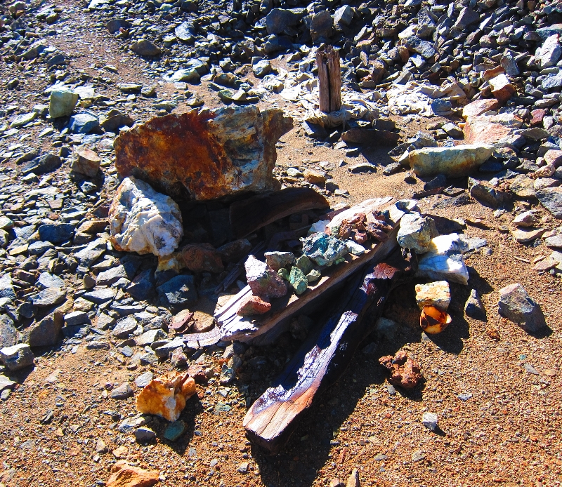
 |
Remnants from the mine.
|
 |
Remnants from the mine.
|
 |
Old mining tools.
|
 |
| Entry to the copper mine. |
After passing the old copper mine I followed a use trail along the top of the ridge to Coppermine Peak (aka Peak 12,345') and finally Coppermine Pass.
 |
| The use trail along the top of the ridge. |
 |
| The view of Deadman Canyon from the ridge above the coppermine. |
 |
| Coppermine Peak (aka Peak 12,345') |
 |
| The view from Coppermine Peak. |
 |
| The peak register. Andrew Skurka & Rogue Photonic! |
By the time I reached Coppermine Peak the clouds were already starting to cover the surrounding peaks and ridges. I had planned on following the ridge to Glacier Lake in preparation for a climb of Triple Divide Peak, but when the clouds started to cover the high peaks I decided to head down into the safety of Cloud Canyon.
 |
| The view of Triple Divide Peak from Coppermine Peak. |
 |
| Clouds covering Triple Divide Peak. |
 |
| Panorama of Cloud Canyon from Coppermine Pass. |
The route down from Coppermine Pass to Cloud Canyon involves endless scree and boulders, followed by a steep 300 foot boulderfield! Eventually things got much easier and I followed an old miners use trail to the beautiful flat granite slabs and meadows in Cloud Canyon.
 |
| Miles of scree and boulders on the route down from Coppermine Pass to Cloud Canyon. |
 |
| My route down the final 300 foot boulder field. |
 |
| I followed an old miners use trail down into Cloud Canyon. |
 |
| Granite slabs and meadows in Cloud Canyon. |
 |
| Beautiful Cloud Canyon. |
 |
| Easy cross country in Cloud Canyon. |
After descending Cloud Canyon I met the Colby Pass trail at about 9,000' and followed it up toward Colby Lake. The wildflowers made for a pleasant hike and I found a nice place to setup camp before the daily storm arrived.


No comments:
Post a Comment