Last spring while walking the dogs I ran into my familiar neighbor Dwayne. Dwayne has an easygoing personality overflowing with the enthusiasm reminiscent of the relatives I knew as a kid in Ohio. He is recently retired and always friendly while leisurely pruning the gigantic sunflowers in his driveway or polishing his new Lexus. He is often seen hiking up the local hillsides to stay in shape for ski season. No big deal. Just another in-shape 60-something enjoying some snow sports. Little did I know that Dwayne had climbed Mt. Whitney several times. . .he did all 20 miles up to 14,496 feet and back as a day hike. Dwayne scoffs at the people who lounge overnight at the base camp along the way. I noticed he was wearing an old Mt. Whitney t-shirt when he gave me a picture of him on the summit.
There was no time to mention my plans to hike the JMT as he insisted that if it was only possible to do one section on the JMT that his route was the best. On this day he was pouring it on, turning a suggestion into an absolute necessity, something that must be included on ones bucket list. Dwayne went on to explain the details: Hike the John Muir Trail from Tuolumne Meadows to Reds Meadow Resort (near Mammoth) and pass through the best part of the trail; Ansel Adams Wilderness. None of it was conjecture, there were no opinions. Just facts. This route was the best (period).
He was preaching to the choir. I had already started making plans to finish the JMT in three sections. The first 28 miles in July, the next 32 miles in August and the final 160 miles solo in September. After doing the first part solo the second section would follow his suggested plan exactly. A short time later I had the permit for six people to leave Tuolumne Meadows the last week of August. He was in. We started talking about gear, maps and other details. I prefered to include ultralight gear while Dwayne talked about carrying a nine millimeter for bear protection. I thought this was hilarious. . . who would protect the wildlife from Dwayne? It was all harmless. I would bring my wife Candy, old buddy Brad and newer friend from backpackinglight Jerry. Dwayne would bring a young friend just out of the Marines. Our permit for six was full and we were ready to go.
Two weeks before the trip Dwayne walked across the street to my driveway. He didn't sound good. Unfortunately he had been diagnosed with throat cancer and would be starting chemo therapy soon. He and his buddy were out.
For the months leading up to the these trips I had started to feel uncertain about taking so much time off of work. Dwayne helped me see that the time is now. So off we go ~
Day 0:
After staying at the Mammoth Lodge the night before we met Jerry in front of the lodge and took the early Crest shuttle to Tuolumne Meadows. Jerry had already been hiking for most of the week around Yosemite and was eager to start the trip that morning. We had very little sleep the night before just getting ready to get out of town so we decided to stick with the original plan and kick it around Tuolumne Meadows after picking up the permit. We camped in the backpackers camp and after enjoying some tasty food at the TM 'restaurant' we played cards around camp and got to bed early.
Day 1: 11 miles. Tuolumne Meadows to just above the Lyell Fork Bridge.
The next morning we got a relatively early start (for a group) and followed the trail from the backpackers camp to the JMT that Jerry had scouted out. Soon we were enjoying the leisurely hike up Lyell Canyon. Here's the crew on day 1:
 |
| Andy, Candy, Jerry & Brad. |
 |
| We started at Tuolumne Meadows. |
 |
| The water along the Lyell Fork of the Tuolumne River was beautiful. |

 |
| Wildlife in Lyell Canyon. |
 |
| Lyell Canyon: Click for Full Size Pano. |
It's an easy mainly flat hike to the end of Lyell Canyon. Soon Donohue Pass was in view. We would be hiking over the snow covered mountains in the background the next day. . .
 |
| Lyell Canyon with Donohue Pass in the distance. |
We could hear this waterfall from a long way, it's draining from the snowfields above along the Kuna Crest:
 |
| We could hear this waterfall for miles away. This is near the end of Lyell Canyon. The water is draining from snow on the Kuna Crest. |
 |
| Looking back at Lyell Canyon as we hiked up the beginning of Donohue Pass. |
 |
| After hiking up the first 900 feet of switchbacks out of Lyell Canyon we finally reached the Lyell Fork Bridge. We camped nearby after making about 11 miles the first day. |
 |
| Andy & Candy in camp. |
 |
| Jerry chilling after a long day. Being a well prepared UL'er Jerry brought a Kindle (4 oz) with the JMT guidebook already downloaded on it. When it was time to find a good camp at the end of the day he just consulted the JMT guidebook. Jerry was a very welcome part of the group! |
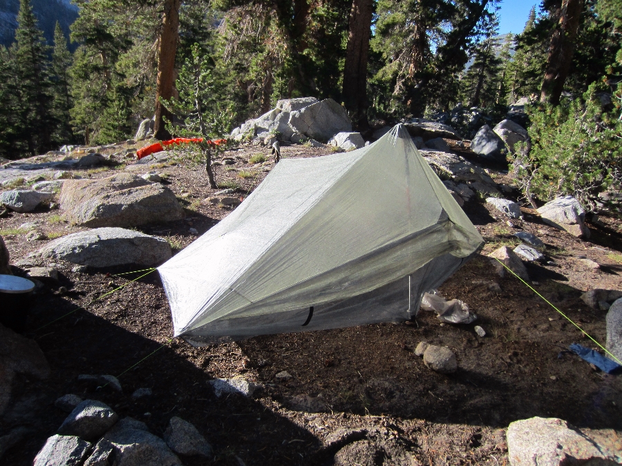 |
| Jerry's Zpacks Hexamid Twin Tent with optional extended beak. 11.1 ozs of cuben luxury. |
Day 2: 8 miles. Lyell Forks Bridge to Thousand Island Lake:
The next morning we started up the final part of Donohue Pass:
 |
| Ready to get head over Donohue Pass. |
Jerry & Brad, trail dudes. Jerry is carrying a Gossamer Gear Gorilla . Brad is trying out a new Osprey Exos.
 |
 
 That is Brad heading down from Donohue Pass on the south side towards Island Pass. The well maintained trail made for an easy hike down.
We descended into this amazing area with crystal clear creeks that meandered throughout the boulders, puffy grass and flowers.
  Soon we had reached the top of Island Pass and into Ansel Adams Wildnerness. |

Video of Candy on top of Island Pass.

We camped along the shore of Thousand Island Lake with amazing views of Banner Peak. We all had dinner on a little peninsula. The color of the water reminded me of the Bajamas, but much much colder. There was actually a sandy bottom which felt great on our sore feet.
Day 3: 10 miles. Thousand Island Lake to Gladys Lake.
 |
| Thousand Island Lake. |
 |
| Thousand Island Lake. |
 |
 |
| Click for Full Size Pano. |

 |
| Click for Full Size Pano. |
 |
| Brad, Candy & Ducks on the trail. |
 |
| The footbridge at the outlet of Thousand Island Lake. |
 |
| Garnet Lake, Mt. Ritter and Banner Peak from the JMT. |
 |
| The footbridge over the outlet of Garnet Lake. |
On the Garnet Lake footbridge.
 |
| Goofing for the camera. |
We camped at Gladys Lake the third night. The lake was cold but the water felt great washing off the days trail dust. We made a quick dinner and enjoyed the sunset on the lake. Candy and Brad were eager to get an early start the next day and get home. . . I was in no hurry to leave the wilderness.
We used a Big Sky International 2 person tent. At the time it was the lightest freestanding 2 person tent with 2 doors and 2 vestibules. They have since started to offer a cuben version that is lighter but over $800. Ouch:).  |
| Gladys Lake the last night. Brad used the Six Moon Designs Gatewood Cape & Serenity Net Tent: |
 |
 |
| Sunset on Gladys Lake. |
 |
| Sunrise on Gladys Lake. |
We got an early start and soon we were at Devils Postpile.
 |
| After getting an early start on day four we arrived at Devils Postpile. |
 |
| The top of the postpiles were, mostly like you would expect. Postpiles with some glacial polishing thanks to the most recent ice age. |
 |
| C'Andrew on top of the postpiles. |

Andy, Candy & Brad at the Postpiles.
This was an easy group hike at a leisurely pace with low daily mileage to keep it fun for all. We hiked about 32 miles in 3 and 1/2 days. This was Brads first experience with lightweight gear and he was hooked. Over the years I have ended up with a bunch of extra lightweight gear and I am always happy to lend UL gear to friends. Brad liked the SMD Gatewood Cape and Serenity Net Tent so much that he ordered his own when he got home.
Candy likes the double wall two person tent (the 'Condo') and the comfort of a full length Therm-a-rest Neo-Air sleeping pad. She sleeps cold and uses a 15 degree sleeping bag to stay toasty warm and comfortable at night. I carried the food, tent and sleeping pads for both of us.
Carrying a heavier pack than usual felt like good training for the 160 mile thru-hike section that I was starting in two weeks. I was definitely ready to do 15 - 20 miles a day.
What worked:
Easy low mileage days for Candy & Brad since this was their first time doing over 5 miles/day.
Lightweight home made quilt. I brought a 17 ounce 20 degree rated quilt that was actually too warm. I probably could have used a 12 ounce 40 degree quilt and been just fine.
What didn't work:
Trying to stay together on the trail all day. It would have been easier to just pick a lunch spot and final camp spot and agree to meet along the way.
If you are reading this as part of the JMT 2011 Trip Report follow this link: