Thistrip started with a text from my niece over the winter, "I wanna do a hike on the JMT with my boyfriend this summer, can you help?". Since the iPhone is the preferred method of communication for most twenty-somethings we spent months texting about "the best" trip for them. A short section hike on the JMT was perfect considering this would be there first long(ish) backpacking trip. I outlined a trip for them from Onion Valley to Horseshoe Meadows with a side trip to Mt. Whitney.
At the same time I had been planning a traverse of the Great Western Divide starting from Horseshoe Meadows. . . so I had inadvertently organized a car exchange! After giving them my car I would start at Horseshoe Meadows, travel cross country into Kaweah Basin and follow the Great Western Divide to the northern terminus and hike out to Onion Valley. This way I could do the trip as a thru-hike and cover more ground. . . and hopefully my car would be waiting for me ten days later.
After leaving Phil and Shirley at the Horseshoe Meadows trailhead I was excited to finally get started on the big trip of the summer. Ten days of solitude, ten high Sierra passes, challenging cross country climbs and whatever (mis)adventures that might happen along the way.
The trail to Cottonwood Pass is mostly sandy and flat until the short set of switchbacks to the pass so it was an easy start and soon I was at the top. I had been over this pass a few times and it had become my preferred pass in the Southern Sierra due to the elevation gain of only 1,500+- feet. I loaded up with water at Chicken Spring Lake and continued on feeling strong and making good time.
I passed a group of scouts at the junction of the PCT and Rock Creek Trail and headed down the easy long downhill slope toward the creek a few miles ahead. Unfortunately I started to feel a hot spot, or maybe a few hot spots on my right foot. By changing the angle of my feet I could manage but by the time I reached the creek it was time to stop and investigate. To my surprise I had large blisters on my right ankle and right big tow. I have never had a problem with blisters, even after hiking hundreds of miles on other trips in the Sierra. How could this be? And on the first day?!
I was wearing a new brand of trail runners this summer but I had already been on three long warm up hikes with no problems. Maybe it was the slightly heavier pack since I was carrying ten days of food. . . but my total pack weight was only 23 lbs. None of that mattered now. I cleaned up and with moleskin in place I started the 1,500 foot climb to Guyout Pass.
Leaving Horshoe Meadows with food and gear for 10 days.
Foxtail Pines on the way to Chick Spring Lake.
Foxtail Pines along the PCT as the view opens up to the west.
The miles passed and before long I was passing southbound JMT hikers. As I approached a large group covered with a weeks worth of trail dust someone said, "look, we're already seeing Mt. Whitney day hikers!". . . since they were all carrying huge loads I figured they were referring to my small backpack. I responded with a good natured, "Day hiker?! I'm on a ten day traverse of the Great Western Divide bitches". We all laughed and high-fived as I walked by. Someone asked about my homemade backpack and we had a good time talking gear and trail conditions. They couldn't believe I was carrying ten days worth of food and gear. . . and nobody seemed to know about the Great Western Divide.
By 5:00 pm I made it to the switchbacks leading down to Crabtree Meadows and I was ready for a long dinner break. I finished dinner and with several hours of daylight left I continued on toward the junction with Wallace Creek. I had hoped to make the 24 miles to camp at Wallace Creek but within the first mile I was almost out of water and decided to backtrack and make camp at Crabtree Meadows. Over 20 miles for the day was fine and I was in a good place to make an early start on the cross country route into Kaweah Basin tomorrow.
Camping at Crabtree Meadow.
Day 2: 12 miles
Crabtree Meadows to Kaweah Basin
I got an early start and by 10:00 am I was heading down the Wallace Creek trail and into the Kern Canyon 2,500 feet below. This section of trail was new to me. Some of the trail is blasted into the side of the canyon wall and the views were spectacular. I could see where the Colby Pass trail would enter King-Kaweah River valley on the opposite side of the canyon. . . I would be making that climb in a few hours.
Soon the rocky granite walls were replaced by the wooded canyon floor of Kern Canyon and it was hot and humid! While climbing out of the canyon it got up to 99 degrees. I finally had to stop and rehydrate at a creek along the way. It was another miserable hour until I made it to the King-Kaweah River.
The wildflowers were in full bloom and it was an amazing change in scenery. Beautiful lush landscaping and cool water replaced the misery of the hot climb. Some of the trail was completely covered with tall wildflowers up to my shoulders. I was impressed with some of the stone work on the steep switchbacks that were similar to the Golden Staircase on the JMT.
Hiking down into the Kern Canyon.
Hiking down into the Kern Canyon.
Upper Kern Canyon panorama.
Junction Meadow at the bottom of the Kern Canyon.
Steep stone switchbacks on the Colby Pass Trail.
After climbing back out of the Kern Canyon to about 9,200 feet I crossed the Kings-Kaweah River. This section is divided into three smaller rivers with large waterfalls and the route finding was complicated by some bushwhacking on the opposite side. I was concerned about finding the right way up the canyon toward Kaweah Basin but the overall route was easy to follow. The east fork of the Kaweah Basin outlet creek is hard to miss and there were a few ducks at the entry to the creek.
Granite slabs along the east side of the creek made for challenging cross country travel and although I wasn't fully acclimated it was possible to make decent time with a few stops to enjoy the waterfalls. I crossed the log jam at 10,140+- feet and started the final climb on the right side of the waterfall. There was a short class III section but nothing too difficult or dangerous. The incline eased as I finally reached the entry to Kaweah Basin. The outlet creek flowed between the granite slabs and created beautiful shallow pools where the terrain allowed. Finally I reached the first lake in the basin with the view of the giant Kaweah Peaks reflected in the water. Classic Sierra. Totally undisturbed. I passed several flat camp sites, but none of them had evidence of human use. I would spend a few days here and never once saw a sign of another human.
Crossing the Kings-Kaweah River.
Challenging cross country route to Kaweah Basin.
The final Class III climb to Kaweah Basin.
By the time I reached Kaweah Basin storm clouds were approaching and there wasn't much time to explore for a place to camp. I setup my tarp between some boulders and a few trees, made a quick dinner and sheltered up just in time for the light show. I got into the 'lightning position' on top of my sleeping pad and listened as the rain turned to hail and the thunder came closer and closer. After a few hours things settled down and there was just some light intermittent rain throughout the night. I am still surprised at how a relatively small 6' x 9' cuben tarp can provide complete protection from the elements in the high Sierra.
The Kaweah Peaks as the storm arrived.
~ Cross country route into Kaweah Basin from the Colby Pass Trail ~
(Click for Full Size)
Day 3: Kaweah Basin
The next morning I awoke to cloudy skies and decided to spend the day exploring the lower part of Kaweah Basin. In most of the trip reports I have read about Kaweah Basin people usually talk about wishing they had spent more time here. I decided to take a 'zero' day and just enjoy the basin.
Ultralight camping with a simple 6' x 9' cuben fiber tarp.
After a relaxing day I had dinner at the top of the waterfall I had climbed the day before. The views stretched all the way to the Sierra Crest to the east, and to the southwest the sun set on the Kaweah Peaks.
Dinner with a view.
Sunset on the Kaweah Peaks.
Day 4: 9.5 miles
Kaweah Basin - PyraQueen Col - Picket Lake
After a relaxing zero day I was re-energized and ready to climb out of Kaweah Basin via PyraQueen Col and start exploring the Great Western Divide. The plan was to hike to Nine Lakes Basin and follow the GWD to the north, all the way to Bubbs Creek.
The cross country terrain in Kaweah Basin was straightforward and it only took a few hours to get to the base of the boulder fields leading to PyraQueen Col. But storm clouds were starting to gather behind the Kaweah Peaks. . .
Sunrise on the Kaweah Peaks.
A lonely island.
Classic Sierra scenery in Kaweah Basin.
Sierra Crest from Kaweah Basin.
Lower Kaweah Basin panorama.
Kaweah Basin.
Cross country terrain in Kaweah Basin.
Easy cross country terrain in upper Kaweah Basin.
Kaweah Peaks panorama.
Storm clouds rolling in behind the Kaweah Peaks.
Looking back into Kaweah Basin on the way to Pyra Queen Col.
Boulder fields on the way to Pyra Queen Col.
The route to PyraQueen Col.
The climb through the boulder fields was slow but fun. Unfortunately as I got closer to the top storm clouds began to collect on the other side of the Kaweah Peaks. I looked back into the basin and saw dark storm clouds dropping snow onto the peaks to the east. I was actually higher up than where the snow was falling and I could see dark clouds blowing over the pass toward me. After experiencing the thunder storms a few days prior at lower altitude I didn't want to get caught up here if the lightning started again.
Storm clouds approaching in Kaweah Basin.
Storm clouds approaching over PyraQueen Col.
Click for Video: Storm Clouds Approaching
Once I got back down to the safety of lower elevation and the storm eventually passed the flowers and meadows came alive. The dusting of snow was visible on the peaks and ridges across the basin.
Kaweah Basin after the storm.
Kaweah Basin after the storm.
Upper Kaweah Basin after the storm.
Upper Kaweah Basin.
Since I couldn't make it over to Nine Lakes Basin I decided to cross over Picket Creek Pass and to Lower Picket Lake for the night. There was a small group at the designated camp on the shore of lower Picket Lake but one of the people recommended camping on the bluff above. To my surprise there was a good flat spot to camp and amazing views from the top of the bluff. I had dinner and watched the sunset on the Sierra Crest from my private granite perch.
Cross country terrain on Picket Creek Pass.
The top of Picket Creek Pass.
Long shadows from Picket Creek bluff camp.
Alpenglow on the west side of Mt. Whitney from the bluff camp.
Day 5: 6.5 miles
Picket Lake to Milestone Bowl
By this point in the trip I was feeling fully immersed in the wilderness. I like the freedom of being completely self sufficient with only the most basic essentials. Each summer since 2011 I have taken a 10 day trip like this and it's something I look forward to every year. Waking up to the sunrise on Mts. Whitney, Williamson, Tyndal, Bernard and the rest of the Sierra Crest across the Kern Canyon was amazing.
I enjoyed a late start (aka slept in) and after exploring the lake I headed down the easy cross country route to the Colby Pass Trail. Easy granite slabs were like a natural stairway down to the turnoff where the slope cliffs out. A left turn along the slope leads to a series of benches and eventually to the Kings-Kaweah River and Colby Pass Trail. I took a break and washed up along a wide portion of the river with a large flat shoreline of mostly polished granite. I though about how people pay big money to get this kind of setting in their master bathrooms back home.
I crossed the river and followed the Colby Pass Trail toward Gallats Lake.
Morning view from Picket Creek bluff camp.
Lower Picket Creek Basin from bluff camp.
Picket Creek Basin panorama. Lower Picket Lake is on the far right.
Cross country route from Picket Creek Basin to Kings-Kaweah Canyon.
~ Cross country route from Kaweah Basin to the Colby Pass Trail ~
(Click for Full Size)
Once I got to Gallats Lake the wildflowers and wind created a perfect storm of airborne pollen and I started to suffer from allergies. I've never brought allergy medication on these long hikes but I definitely could have used it in this canyon.
Soon after Gallats Lake the Colby Pass Trail starts to climb up the north side of the canyon toward Colby Pass. Some of the trail here is not really a trail at all and in some areas it's like a very steep riverbed made up of small loose boulders. The climb was worth it. I was surprised by the beauty of the plateau below Colby Pass. I stopped for dinner here and enjoyed the scenery before starting the climb to Milestone Bowl.
The cross country climb to Milestone Bowl was straightforward. I camped near the lake at the top with great views of the Kaweah and Picket Guard Peaks across the Kings-Kaweah River canyon.
Gallats Lake.
Dinner with a view in Milestone Bowl.
Wildflowers on the climb to Milestone Bowl.
Camp in upper Milestone Bowl.
Day 6: 6.5 miles
Milestone Bowl - Milestone Col - Milestone Basin
The lake at the top of Milestone Bowl was beautiful and I could have spent an entire day here, but I was anxious to get an early start up Milestone Col and get over the top before any afternoon storms.
The terrain on the way to the top of the west side of Milestone Col was mainly an easy boulder scramble with a short steep climb at the top. The wind was really blowing at the top and I held on to the last boulder while taking a look at the other side. I knew there were very steep cliff walls on the southern side of the Col. Fortunately I made it to a good place to cross and I could see a way down right below. The pass is rated class II but there was one easy class III move at the top. The rest of the way down starts with a scramble down large steep boulders followed by a long talus field.
Once past the boulders the terrain is made up of mostly gentle granite walkways that follow creeks and waterfalls along the entire basin. Toward the lower portion of the basin I found the remains of a use trail that followed along the north side of the creek. By late afternoon I made it to the Lake South America trail and followed it north to the outlet of an un-named lake somewhere in the upper Kern Basin. I cowboy camped, but this was one of the few places with mosquitos. By 9:00 they disappeared for the night and I could sleep without a head net.
Milestone Bowl.
Milestone Pass from Milestone Bowl.
My route to Milestone Pass on the west side.
The pass is on the left. The X leads to cliffs on the west side.
Milestone Pass.
Milestone Pass.
Milestone Pass.
Steep terrain from the top of Milestone Pass.
It was windy at the top.
Two minute video from the top of Milestone Pass
Class II+ wall on the east side of Milestone Pass.
View to the east from Milestone Pass.
Pano view to the east from Milestone Pass.
Milestone Basin panorama.
Cliff at the top of Milestone Pass.
Milestone Pass from the west.
Scrambling down the west side of Milestone Pass.
Milestone Pass from the west side.
Milestone Pass from the west side.
Milestone Peak panorama.
Milestone Peak from lower Milestone Basin.
Milestone Basin.
Milestone Basin.
Cowboy camping somewhere in the Upper Kern Basin.
Sandy beach along an anonymous lake.
Day 7: 6.5 miles
Thunder Basin
The plan for today was to explore Thunder Basin, cross Thunder Col and camp at Longley Lake. I started out at an amazing lake at the entry to the basin. This lake had it all: good sized sandy beaches, several existing camp spots, great views and lots of opportunity for climbing nearby.
The creek and waterfalls in Thunder Basin were beautiful and the entire basin seemed untouched by humans. After a series of large benches the terrain got more rugged and I scrambled up the boulder fields to explore the upper lakes. The two huge lakes were crystal clear and it felt like I would fall to the bottom if I fell while sitting on a rocky outcropping along the shore. By late afternoon I made it to the upper lake and finally to the pass at the top of the basin.
Although the south side of Thunder Pass was a straightforward scramble, the north side was mainly a vertical cliff! I climbed along the wall at the top but couldn't find a way down until I reached the chute on the far west side. I could see a slightly worn area where it looked like people had ascended or descended in the past, but the chute was made up of very loose sand and small rocks with nothing to hold on to. To make things worse the angle of the chute was steeper than anything I had seen before and the bottom section was not visible. Although I had climbed several class II and class III cross country passes in the Sierra this was beyond my comfort zone as a solo hiker. After taking a fall last year I made a promise to my wife that I would not do anything that I wasn't 100% sure of. I decided to head back down.
It wasn't a total loss because I got more time to fully enjoy Thunder Basin. I ended up camping near a series of waterfalls in a large open area of the basin. The full moon that night lit up the walls of the basin. Another beautiful spot.
Unnamed lake at the entry to Thunder Basin.
Thunder Basin.
Thunder Basin.
Thunder Basin panorama.
Thunder Lake.
Thunder Lake.
Thunder Lake.
Thunder Peak and Thunder Pass from Thunder Lake.
The view to the east from Thunder Pass.
Cliffs on the north side of Thunder Pass.
Steep chute on the north side of Thunder Pass.
The view from the top: Thunder Pass Video
Dinner on a ledge below Thunder Pass at 12,400 feet.
Ultralight cooking setup.
Camping in lower Thunder Basin.
Thunder Basin panorama (stitched from several photos).
Day 8: 13 miles
Thunder Basin - Forester Pass
I spent the morning exploring the lake at the entry to Thunder Basin and navigating the complex terrain in the Upper Kern Basin on the way to the Lake South America trail. Once I made it across the Kern Basin the view of the Great Western Divide opened up. This is a beautiful area that I hadn't expected to see during this trip and the wide open vistas made for panoramic views in all directions.
This area is remote and seems to have remained unaffected by humans. It takes at least two days to reach this part of the Upper Kern from the closest trail heads. As I crossed through the many mini valleys, creeks and tarns I couldn't help but think this would be a good place to hide out from society.
Once I reached the turnoff to Lake South America I decided to head over to Forester Pass and camp on the plateau on the north side. I remembered a pastoral area with a creek and many flat areas to camp on the north side from my JMT thru-hike in 2011. It was one of the places I had always wanted to see again and this was the perfect opportunity. Also, the blisters from a week ago weren't getting any better and I had already used everything from my first aid kit. Spending some time on a well worn trail would be a welcome change.
I slid down the sandy south side of the Lake South America Trail and down toward the JMT junction. I made a cross country detour and contoured eastbound at about 11,600 feet toward the JMT and before long I was socializing with other hikers. I ran into an experienced hiker and his girlfriend who were using some cool vintage GoLite gear from the mid 1990's. I had no idea GoLite was making gear back then.
I watched several hikers descend the switchbacks on the south side of Forester Pass while taking a long dinner break in a grassy meadow by one of the lakes. By this time I was fully acclimated and after dinner the climb up the well engineered switchbacks felt effortless. After a few photos at the top I headed down the luxurious trail on the north side. The stone work on the stairs and switchbacks on the way down looked like something out of a luxury custom home. The CCC crews have been doing high quality work!
I made camp in the trees above the trail and watched another beautiful sunset. I realized this would probably be my last night in the wilderness on this trip. I had made a few changes to my original plan and did not finish the journey along the Great Western Divide. . . but everywhere I had been was beautiful and I would be back.
Thunder Basin from Unnamed Lake.
Upper Kern Basin.
Great Western Divide from the Lake South America trail.
Great Western Divide panorama.
Great Western Divide panorama.
Lake South America trail.
Cross country terrain.
Forester Pass panorama.
Approaching Forester Pass.
Donald Downs memorial.
Donald Downs memorial and Forester Pass.
The view from the top of Forester Pass.
13,200 feet at the top of Forester Pass.
The view to the north from Forester Pass. The Center Peak fire is visible in the foreground.
Camping below Forester Pass.
Day 9: 14.5 miles
Forester Pass - Onion Valley
This was my last day so I slept in knowing that I only had about 14 miles to cover on the way out. . . and it was all on trail! The blisters and allergies finally won out to the comforts of civilization. Cheese burger. Shower. Real bed.
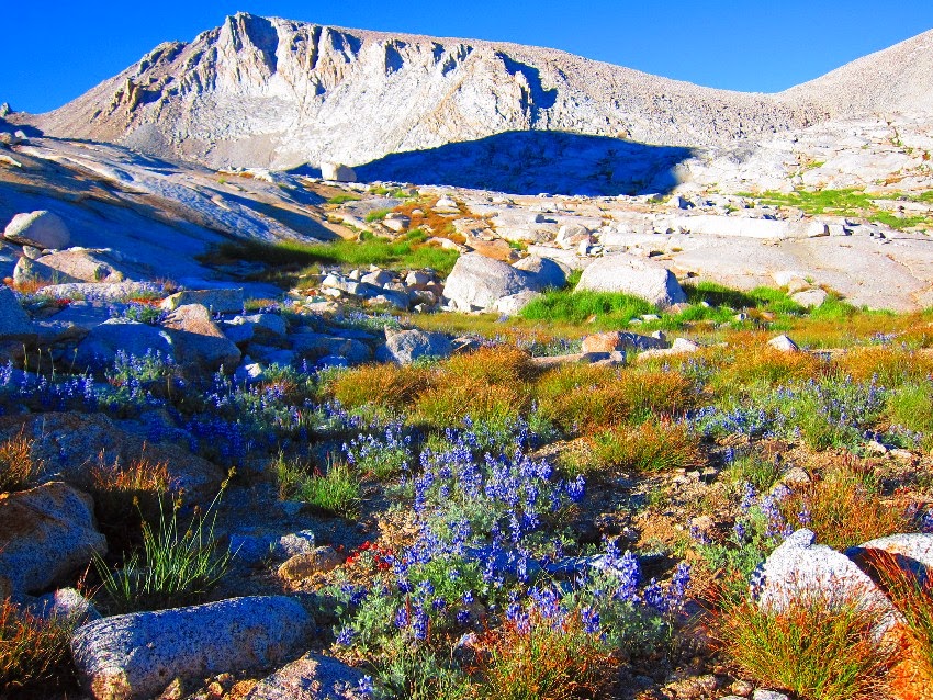
But first more wildflowers. I have never seen such amazing wildflowers this late in the season.
Wildflowers on the JMT below Forester Pass.
Wildflowers on the JMT below Forester Pass.
More wildflowers on the JMT below Forester Pass.
On the way down I found this sign about the Center Peak fire. It was started by lightning and the rangers asked that people just let it burn.
The Center Peak fire.
And I met some fellow UL backpackers along the way. They were finishing the JMT in 10 days and had hiked through most of the thunderstorms we experienced the week before. Hardcore!
Some fellow UL Gearheads with their matching Gossamer Gear backpacks.
My trusted Gossamer Gear LT3 trekking poles.
While hiking up the switchbacks toward Kearsarge Pass I could see more monsoonal storms building in the backcountry. I was leaving just in time.
East Vidette Peak.
Kearsarge Lakes.
Big Pothole Lake near the top of Kearsarge Pass.
Almost home. Owens Valley visible in the background.
Rocky switchbacks down to the Onion Valley trailhead.
My car waiting at the trailhead.
Phil and Shirley had parked my car right at the trailhead. What a great way to end a trip. Even though I didn't get to finish the Great Western Divide on this trip it was an adventure and I will be back for more!
~
Great Western Divide Video:
~
For some information about the gear I used on this trip check out these links:


No comments:
Post a Comment