Showing posts with label sierra high route. Show all posts

XST 2016 ~ Cross Country Sierra Traverse

Mt. Ansel Adams along the XST - Cross Country Sierra Traverse

This year the mountain gods provided a tremendous opportunity. . . a three week window during the prime summer season to explore the High Sierra. Through a series of unplanned circumstances my usual one week trip morphed into a three week epic adventure! After pouring over maps and considering many possible routes I finally settled on a cross country traverse of the High Sierra. . . I stitched together portions of the Sierra High RouteSouth Sierra High RouteKings Canyon High Basin Route along with some of my favorite cross country alternatives to create a cross country traverse of the High Sierra. 

In the end I climbed 25 High Sierra Passes over 257 miles in 22 days. I started preparing for the trip in January and followed Alan Dixon's training program which included long weekend hikes up to 30 miles per day leading up to the start in July. Some of the climbs and long days were more challenging than I anticipated and the fields of wild flowers at the beginning almost derailed the whole trip. Although I planned on climbing 31 passes over 295 miles I had to skip the sections from the Lyell Fork to Mammoth and Ionian Basin due to allergies. Fortunately I was able to re-energize during a zero day and get back into the wilderness to finish the route. 

Many thanks to the endless support from my wife Candy. I missed you! 


~ XST 2016 ~ 


Cross Country Sierra Traverse: 25 Passes over 257 miles.
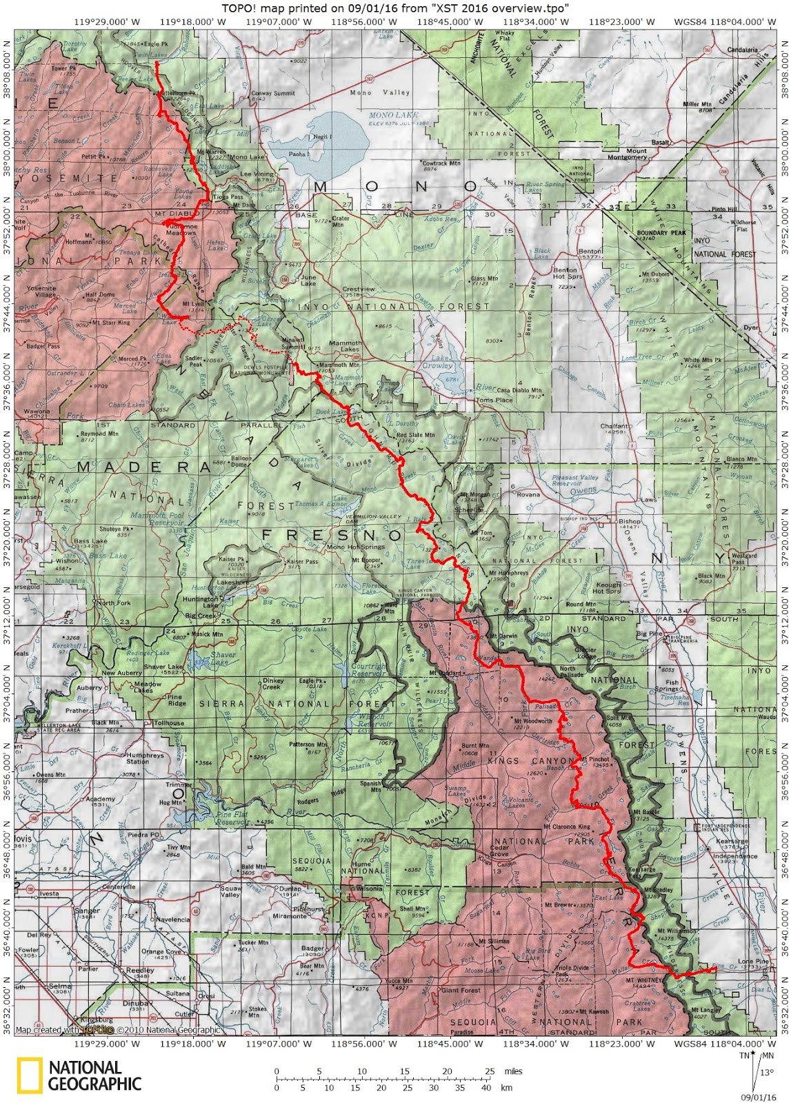


XST 2016 ~ Cross Country Sierra Traverse

Sierra High Route & Mono Divide: 06/26 - 07/02/2013


Pinecreek Trailhead.

This trip was originally planned to be an 11 day SHR section hike from Merriam Lake to the Silver Divide and back via the PCT. I had planned a few layover days to enjoy Lower Mills Creek Lake and Bear Lakes Basin. . . but by the time I finished a few last minute gear projects (a new backpack, sleeping quilt and stove) the plan was compressed into an 8 day loop with no 'zero' days. 

So with a new more comfortable internal frame backpack and 8 days of food I headed up the switchbacks from the Pine Creek trailhead. The first 2,000 feet to Lower Pine Lake made for a steady but reasonable climb. I enjoyed a nice breeze and long lunch break along the outlet creek. 

For the rest of the day the bugs chased me through Granite Park. 

Whitebark Pass Route Detail

For anyone interested in Whitebark Pass here are a few details of the 'Roper Route' or Sierra High Route and an alternative that I took on the north side. 


This is the view of the approach to the south side of Whitebark Pass. One of the Nydiver Lakes is visible on the right. Ropers description of the two stands of Whitebark Pines was helpful here.


Minaret Loop ~ July 15th - 17th

I have been wanting to get an up-close and personal look at the Minarets ever since I rushed by them (much too quickly) while thru-hiking the John Muir Trail a few years ago. Their dark volcanic spires are beautiful and striking against the collection of small alpine lakes at the base of the range. 

After spending much of the winter diligently studying Steve Ropers cross country route that traverses the area I was ready to hit the trail. . . or off-trail as much of the route required. 

Fortunately a three day window of time opened up on the way back from another trip in the northern Sierra this summer. . . So with permit in hand I was ready to leave from the Devils Postpile trailhead near Mammoth Lakes. 

The first river crossing near Devils Postpile National Monument:


Sierra High Route 2012 ~ Trip Report

Marion Lake and Cirque Crest on the Sierra High Route.
The Sierra High Route is a cross-country hiking route, 195 miles long, through the Sierra Nevada. It was scouted by Steve Roper and described by him in his book Sierra High Route: Traversing Timberline Country

SHR 2012 ~ Days 8 and 9: LeConte Canyon to Sabrina Basin


LeConte Canyon.

I left my comfortable camp and got an early start up the switchbacks of the JMT along upper LeConte Canyon. I would be leaving the Sierra High Route at Echo Col and eventually back to my car at the Sabrina Basin trailhead. 

SHR 2012 ~ Day 7: Palisade Basin to LeConte Canyon


Dan at the top of Potluck Pass.
Day 7 started with Potluck Pass. This was an easy pass that leads to the rest of Palisade Basin. After an easy scramble we were at the top enjoying some amazing views.

SHR 2012 ~ Day 5: Marion Lake to Upper Basin

Lake Basin.

On Day 5 we traveled cross country through some of the most remote and beautiful areas of the High Sierra.


SHR 2012 ~ Day 6: Upper Basin to Palisade Basin

Frozen Lake Pass & Vennacher Needle from Upper Basin.
By Day 6 we joined the JMT in Upper Basin and for the first time in four days saw other hikers. 

SHR 2012 ~ Day 4: Horseshoe Lake to Marion Lake

Tehipite Dome from Windy Ridge.

On day 4 we got an early start and began contouring north toward Windy Ridge. It was easier than I expected to route find through the sparse forest. I was mostly eager to climb the granite passes and ridges, but the early walk through the forest was peaceful and reminded me of the many fall trips I enjoyed as a kid in the San Gorgonio Wilderness. 

SHR 2012 ~ Day 2: Bubbs Creek to Granite Pass

Kings Canyon.

Day 3 started out easy enough. Just a cruise down Bubbs Creek to Roads End. No problem. But by the time we got to the Copper Creek Trailhead it was 12:00 noon. . and hot. 90+ degrees at the start of this mostly exposed hike 5,000 feet up unrelenting switchbacks. I had been in the Sierras every other weekend all summer, climbing Class III passes and getting lots of trail miles in to stay in shape. Although it had been two weeks since my last trip I thought it would be reasonably doable, and it was a challenge but not all that bad.


SHR 2012 ~ Day 1: Onion Valley to Bubbs Creek/Spinx Creek Junction

The start of our journey at the Onion Valley trailhead.
Day 1 started with some logistics. After leaving our cars at the South Lake trailhead near Bishop we took a shuttle to Onion Valley. Although it was convenient to start and end this section of the SHR from the east side of the Sierra it meant that our first day would be spent hiking toward the official start of the route at the Copper Creek trailhead at Roads End. By the time we made it to Onion Valley it was already 10:30 am.

SHR 2012 ~ Day 3: Granite Pass to Horseshoe Lakes

Grouse Lake
Day 3 was the beginning of the cross country section of the SHR. After hiking a short time to the top of Granite Pass we left the trail and contoured northeast to Grouse Lake. The water in this pristine alpine lake was beautiful.