The easiest way to access the cross country route to Haeckel Col is from Sabrina Basin. It is about six miles on a maintained trail from the Lake Sabrina trailhead to Midnight Lake. Once at Midnight Lake follow the easy granite benches on the east side of the lake to the top of the ridge between Midnight Lake and Hungry Packer Lake.


The right side of the triangular rock is the crossing point. Granite benches provide an easy route.


The view of the west side from Haeckel Col:

Lake 11,808, Mt. Fiske, the Fiske Glacier and Mt. Huxley.

The boulder field on the west side. There is an amazing view all the way to the Minarets from the first notch below Donn.

The Class III route down the west side of Haeckel Col:

Farther down the boulder field on the west side:

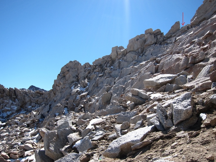
The route from the top of the west side. While facing down toward Lake 11,808 avoid the rocky cliffs on the right and the steep smooth granite wall (not visible here) on the left:

Looking back at the west side approach to Haeckel Col from Lake 11,808. Avoid the rocky cliffs to the left and the giant smooth granite wall on the right. There are some use pathways that help find the way between the cliffs on the left and granite wall on the right:

Looking back at the west side approach to Haeckel Col. The route is partially obstructed by the rocky cliffs on the left:


The route up the ridge from Midnight Lake:

Follow the top of the ridge heading uphill/southwest:

Looking back from the top of the ridge between Midnight Lake and Hungry Packer Lake. Moonlight Lake is the greenish lake in the background:

When this ridge levels out continue to the west and stay to the immediate left of the pointy ridge. Avoid descending to the lakes on either side. There are some ducks along the route, but it is necessary to climb up along the left/west side of the pointy ridge to find them. The climb over this obstacle can be challenging, but keep climbing around the left side. It is sometimes necessary to ascend to avoid cliffing out. Once over this pointy ridge the large valley that eventually leads to Haeckel Col comes into view.
The view of the valley that leads to Haeckel Col:

Looking back while hiking up the canyon. The 'pointy ridge' is visible on the left. The red route line shows the way around:

At the west end of the valley is Lake 12,345. Haeckel Col is visible from the lake (see red arrow):

There are several use 'trails' up this boulder field to Haeckel Col.
Looking back at Donn on the way up the boulder field from Lake 12,345:

Haeckel Col approach from the east side:


The right side of the triangular rock is the crossing point. Granite benches provide an easy route.
The views from the top are awesome! Mt. Haeckel from Haeckel Col:

The view of the west side from Haeckel Col:

Lake 11,808, Mt. Fiske, the Fiske Glacier and Mt. Huxley.

The boulder field on the west side. There is an amazing view all the way to the Minarets from the first notch below Donn.


Farther down the boulder field on the west side:

The route from the top of the west side. While facing down toward Lake 11,808 avoid the rocky cliffs on the right and the steep smooth granite wall (not visible here) on the left:

Looking back at the west side approach to Haeckel Col from Lake 11,808. Avoid the rocky cliffs to the left and the giant smooth granite wall on the right. There are some use pathways that help find the way between the cliffs on the left and granite wall on the right:

Looking back at the west side approach to Haeckel Col. The route is partially obstructed by the rocky cliffs on the left:

Easy scrambling on the way to Sapphire Lake. Mt. Haeckel and Haeckel Col visible in the background:

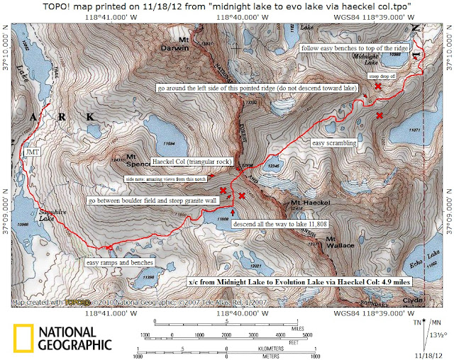
A detailed map of the cross country route over Haeckel Col:

For even more details of the route I did an amateur Haeckel Col movie:
Thanks for reading! Andy.
Thanks for a fantastic trip report and route description. I've been eyeing this one for a while now and had zero info except topos. Twice up to Hungry Packer in the last three years I thought that would be the way, but obviously you took a better route.
ReplyDeleteBill LeMenager
wtvm53@cox.net
01Feb13
Thanks for your comment Bill! It's good to hear the route description was helpful, and that somebody is actually reading this stuff! I was also hard pressed to find any info online about the route. Piero Scaruffi has some good info on his site: http://www.scaruffi.com/monument/hikes07/darwin.html. He is a seriously fast hiker and does most of these class III routes as part of a day hike. Ouch.
DeleteLooks like Piero went from HP Lake like I had in mind. Still your route from Midnight appears safer and saner. Got your email. I'll send a Word doc of "An Epic High Sierra Trek in 1974" if you're interested. At 16 yrs old two pals and I crossed Kings/Kern Divide (twice) and all over the place for 10 days...!
DeleteBill L
wtvm53@cox.net
Great info. This June, I am heading over Lamarck Col and back via Haeckel. The few trip reports I have read are heading over Haeckel in the other direction (E-W). Both sides look firm and fairly straightforward.
ReplyDeleteAny particular issues that your recall heading from Evolution to Sabrina?
No issues heading from Evolution to Sabrina. The cirque/hanging valley above Sapphire Lake is beautiful and should have some nice flowers in June (considering the early melt this year). The route finding from Lake 11,808 is easier on the way up, just stay between the steep rock face on the right and the rocky cliff section on the left. There was a duck just below the col on the west side. The light colored triangular shaped rock is the spot. Have fun!
DeleteForgot to say...thank you for the response!
DeleteAndy D -- Bill L here we just got back from our annual trek from Sabrina trailhead. The reservoir is very low and the snowpack not large. We did a day hike from Moonlight/Sailor up past the "pointy ridge" to 12,000' level and had lunch. Stunning. Haeckel Col was within site and range. Perhaps another year. Next year it's Mt Tom from Horton Creek trailhead. 6,000'+ vertical. I'll be 56. No problemo.
ReplyDelete6,000' vertical, ouch. That sounds like the climb to Whitney or Taboose Pass and Shepherd Pass. I hope you have a great time! Pictures???
DeleteCheck your email!
DeleteBill L
Very nice article. I enjoyed reading your post. very nice share. I want to twit this to my followers. Thanks !. Cross Country Movers
ReplyDeleteThanks for this detailed description. I go up tomorrow!
ReplyDeleteBern-how was your experience going over Haeckel Col? Were you able to easily find your way over and down based on the trip details provided here?
Delete