 LeConte Canyon. I left my comfortable camp and got an early start up the switchbacks of the JMT along upper LeConte Canyon. I would be leaving the Sierra High Route at Echo Col and eventually back to my car at the Sabrina Basin trailhead. Along the way I started to meet other hikers on the well traveled JMT. One of the more colorful characters I met was Al who was working on the his trailguide available at Tahoetowhitney.com.
I started from the JMT in upper LeConte Canyon. The first goal is to climb to the Lake 11,428 at the top of this ridge. From the photo this looks like a small climb, but it is actually a 600 foot wall.
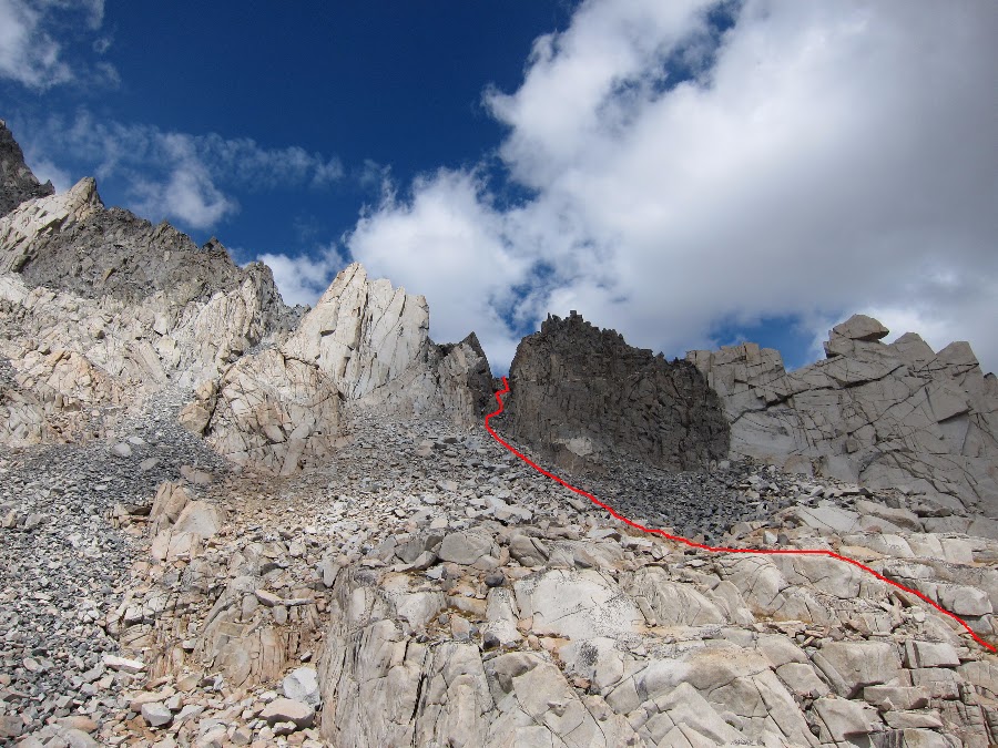
Here is my route up the first climb to Lake 11,428.

For a better perspective this is a picture of the route to Echo Col. This photo was taken from the top of Black Giant.
The climb up the first ridge is steep with a combination of loose talus and some granite cliffs. There was just one Class III section. 
The steep climb up the first ridge.

The view back toward the JMT and Black Giant from the top of the first ridge.
There is a beautiful lake in the small cirque at the top of the ridge. In these remote areas the lakes are just named after the elevation; Lake 11,428. There were a few previously used camp sites on the south shore of the lake.

The route from Lake 11,428 up toward Echo Col.
The views got even better. This is looking back toward Black Giant from the top of the second ridge.

Lake 11,428 and Black Giant from the second ridge.
Finally Echo Col comes into closer view. There is a smaller cirque at the top just below the col. The scale of this area is difficult to capture in these photos. The col looked like it was part of a giant granite wall surrounded by talus.

Echo Col from the cirque. The actual crossing is not visible from this
This is a series taken from the final Class III scramble to the top.
 
After scrambling up the very steep and loose talus field there is a final climb to the top. The views in both directions are amazing. The north side is steeper and the upper section is a cliff face for much of the way. Another hiker told me later that day that a small group of hikers tried to cross the col at the wrong place. They ended up climbing down the very steep cliff face on the north side. Ouch.

The steep loose talus on the way to Echo Col.

The view to the south from the top of Echo Col.

Steep cliffs on the north side of Echo Col.
I could here blocks of ice crumbling and falling of the cliff walls. This was a cold, somewhat dark and uninviting place.
From the top of the col I could see what looked like a small red tent, or possibly a red back pack. I though it was a base camp and I searched the walls of the cirque for a climber, but never found one. Many times I though I could hear a climber but it must have been the ice falling from the cliffs.

The cirque on the north side of Echo Col. Click for full size panorama.
There is an obvious Class III chute on the north side of the col that leads to a loose talus field. Once at the talus field there are several use trails leading down.

Steep Class III chute.

Looking back up at the Class III chute.

Steep talus field on the way down.

Although it looks like a vertical wall to the top of Echo Col it was actually a fun climb down.

There was not much left of the old ice field at the base of the col.

There was a crash site at the bottom of the cirque. Due to the low snow levels during the previous winter and my arrival in late September most of the ice field was melted out. It turns out this is from a crash in 1983.
  
Once out of the cirque the views opened up. This is the view looking north from ridge above Echo Lake.

Echo Lake.
After initially having some trouble finding the way I found the route along the western shore of Echo Lake.

It was getting late in the day and the afternoon shadows were apparent on Moonlight Lake. I made it down through the meadow between Echo Lake and Moonlight Lake and finally camped on the short of Sailor Lake.

Meadow below Echo Lake.
.JPG)
Camping on Sailor Lake. Picture Peak in the background.
The next morning I woke to beautiful warm weather for my final hike out of the wilderness. I met another hiker named Don on the way out. We talked gear, politics, the Sierras and the details of our trips. Don and I would end up coming back to Sabrina Lake in a month to hike over Haeckel Col.
It was only a mile to the hikers parking lot from the Sabrina Lake trailhead. Soon I was heading down to Bishop for the usual post hike cheeseburger.

The view looking back toward upper Sabrina Basin.

Sabrina Lake trailhead.
Here is a short video about the route over Echo Col:
And, some overview maps from days 8 and 9:

SHR 2012 ~ Day 8 map.
 |
SHR 2012 ~ Days 8 and 9: LeConte Canyon to Sabrina Basin


Subscribe to:
Post Comments (Atom)
No comments:
Post a Comment