This spring my hiking compadre Karl extended an invitation to join him on his annual early season hike on the PCT. I am used to snow in the High Sierra, and I usually bring snowshoes and serious winter gear. . . but Karl assured me that in the early spring we could go without the usual winter setup and hike on the snow with trail runners. I watched the forecast and snow level indicators online, and it looked like we lucked out and would be enjoying a rare week-long window of sunny skies and plenty of hard packed snow!
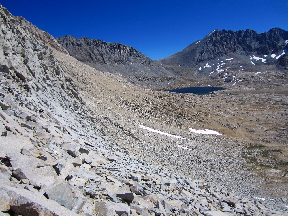
Taboose Pass - Center Basin - Lake Marjorie - Bench Lake
With only a few more days of good weather before the first real winter storms hit I headed up Taboose Pass for a five day cross country solo trek. Taboose Pass is one of the four steep passes that provide relatively quick access over the Sierra Crest and directly into the High Sierra. The price for such convenient access are big climbs of around 6,000 feet in under 10 miles. In the summer a very early start is required to avoid the hot temperatures at lower elevations, but by starting in the fall the weather was enjoyable the entire way.
Once over Taboose Pass the plan was to cross three off-trail passes into some remote basins that have been on my radar for a few years. The fall colors were beautiful but unfortunately there was enough snow lingering on the north facing slopes that I had to avoid my cross country plans and stay in the relative safety of Center Basin, Lake Marjorie and Bench Lake.
I left my comfortable camp and got an early start up the switchbacks of the JMT along upper LeConte Canyon. I would be leaving the Sierra High Route at Echo Col and eventually back to my car at the Sabrina Basin trailhead.
Day 7 started with Potluck Pass. This was an easy pass that leads to the rest of Palisade Basin. After an easy scramble we were at the top enjoying some amazing views.
Tarn above Guitar Lake to Whitney Portal: 16.5 Miles
Sept. 22nd, 2011.
I woke up to the sound of groups of hikers passing by at 3:45 am. They were heading up the switchbacks by headlamp. I wasn't comfortable hiking on an unfamiliar trail at high elevation by headlamp, so I relaxed and dozed off.
Within an hour or so I could see their headlamps on the side of the mountain, way way up toward the top. A friend had told about seeing this same thing many years ago, and now here I was.
By 6:30 am I had gathered my gear and while wearing every piece of clothing I had I started up the trail toward Mt. Whitney. For the first 20 minutes it was seriously cold, but soon I removed almost everything and hiked there rest of the way in shorts with silk long johns, a wind breaker and lightweight hat/gloves.
The views of Mt. Hitchcock and Hitchcock Lakes in the sunrise was beautiful. While hiking up toward Trail Crest I passed a few bivy camp sites (possible camp spots for next time). The trail was basically dug out of the granite most of the way. There was a storm passing from the east and although it was sunny there was snow blowing over from the other side of the ridge.
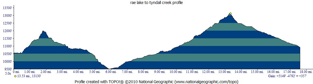
Tyndall Creek to tarn above Guitar Lake: 13.5 Miles
Sept. 21st, 2011.
This was a relaxing day with low mileage and easy terrain. I stopped to clean up a bit at the Tyndall Creek crossing and made my way through some lightly forested areas toward the Big Horn Plateau. The amazing views of the Kaweah mountain range started to open up through the trees. . .
After seeing some of the cuben hybrid material used on the Zpacks Exo backpacks, I decided to try some on my own version of a cuben pack.
The idea with this pack is to make something big enough to hold a Bearikade Weekender or Expedition bear canister plus some winter gear, but still keep it around 8 ozs. I made one out of just cuben and used it on the JMT last summer, but calling it a 'prototype' would be pushing it. People usually passed me and said, "hey, homemade pack heh?". To make things worse it was made out of some bright blue cuben I got on sale on gearswap.
I also wanted something that would hold up to 35 - 40 lbs if I needed to carry extra stuff for a few miles to our favorite Sierra waterslides this summer. I added channels for a removeable internal frame (taken from a GG Gorilla) to handle heavier loads.
Plus, I wanted something that could take some serious abuse on the Sierra High Route this summer.
The material is all available at Zpacks.com. The cuben hybrid is made from 1.43 oz black cuben on the inside and 50 denier polyester on the outside. It feels strong and tear resistent.
For the pack design I borrowed generously from the Blast and Gorilla packs. For the shape of the shoulder straps I traced a North Face daypack. Some of the more original things added are adjustable elastic cords at the top of all the exterior pockets and adjustable pad straps. I like having two medium sized rear pockets instead of one large pocket. It makes it easier to find stuff after a long day.
The cuben hybrid material is attached to the bottom 3" of the pack and side pockets using a triple stitched flat felled seam. All of the attachment places are reinforced with cuben bonded to the main material at a 45 degree angle. The area where the shoulder straps attach to the main pack is triple reinforced. The internal channel for the removeable frame is made from the heavier cuben hybrid material. I noticed that the ends of the frame cut through the channel made from 1.43 oz cuben in the earlier prototype, but the hybrid doesn't rip.
The total pack size is about 3,250 c/i. The main pack bag is 2,500 c/i, side pockets 300 c/i, rear pockets 450 c/i. The main pack is 6" deep, 12" wide and about 34" tall.
The total weight is 9 ozs (without the internal frame). The heavier cuben hyrid material added about 2.5 ozs compared to a similar pack I made with just cuben. The removeable internal frame adds 3 ozs.
Side view (with internal frame and Gossamer Gear sitpad for back padding).
The bottom 3" are made with the more durable cuben/nylon hybrid from Zpacks.com.
Interior detail of the internal frame channels (without the frame)
Interior detail of the frame channels (with the frame)
Adjustable front pocket (open)
Adjustable front pocket (closed)
Adjustable side pocket (open)
Adjustable side pocket (closed)
Shoulder strap attachment detail. There is a third layer bonded at a 45 degree angle inside the pack.
Today was a big day, I wanted to make it over Glen Pass and Forester Pass so I hit the trail by 6:30. The water in Rae Lake was perfectly flat and the view of the Painted Lady was crystal clear. I crossed the outlet of the lake and headed up the switchbacks toward Glen Pass.
Morning on Rae Lakes.
Soon I was at the first plateau on the way up the pass. There were a few beautiful alpine lakes on the right and I could see the trail along the north side of the pass, carved into the mountain. The views on the way up were amazing.
View from Glen Pass.
Video on the way up Glen Pass.
After taking a quick break at the top I headed down toward the tarn on the south side.
Switchbacks on the south side of Glen Pass.
Eventually I descended to Charlotte Lake and started to see groups of people camping along the trail. There are several trail junctions in this mostly flat dusty area and I had read that it was easy to get disoriented here. I was surprised to see one group that was camped right next to the trail with music blasting and some laundry drying on top of a trail sign, covering the sign. After days in the pristine wilderness it was disheartening to see such a lack of common courtesy. Was I becoming a trail snob? Probably, but it really didn't matter, . . . soon I was back in nature.
I made it through the many trail junctions and down the switchbacks to lower Vidette Meadow. I was making good time and before long I was back out of the trees and at the base of Forester Pass. I was chasing the afternoon storm clouds up the pass, but fortunately there was no rain.
Looking back towards Vidette Meadow on the way to Forester Pass.
The trail on the way to Forester Pass.
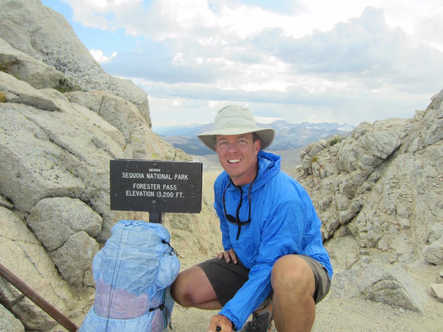
Almost at the top of Forester Pass. Junction Peak in the background.
The view north from Forester Pass, looking back from where I started.
The view south from Forester Pass, looking south toward Mt. Whitney.
Forester Pass (13,200 feet).
The trail on the south side of Forester Pass.
Video looking down the cliff on the south side of Forester Pass.
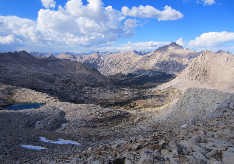
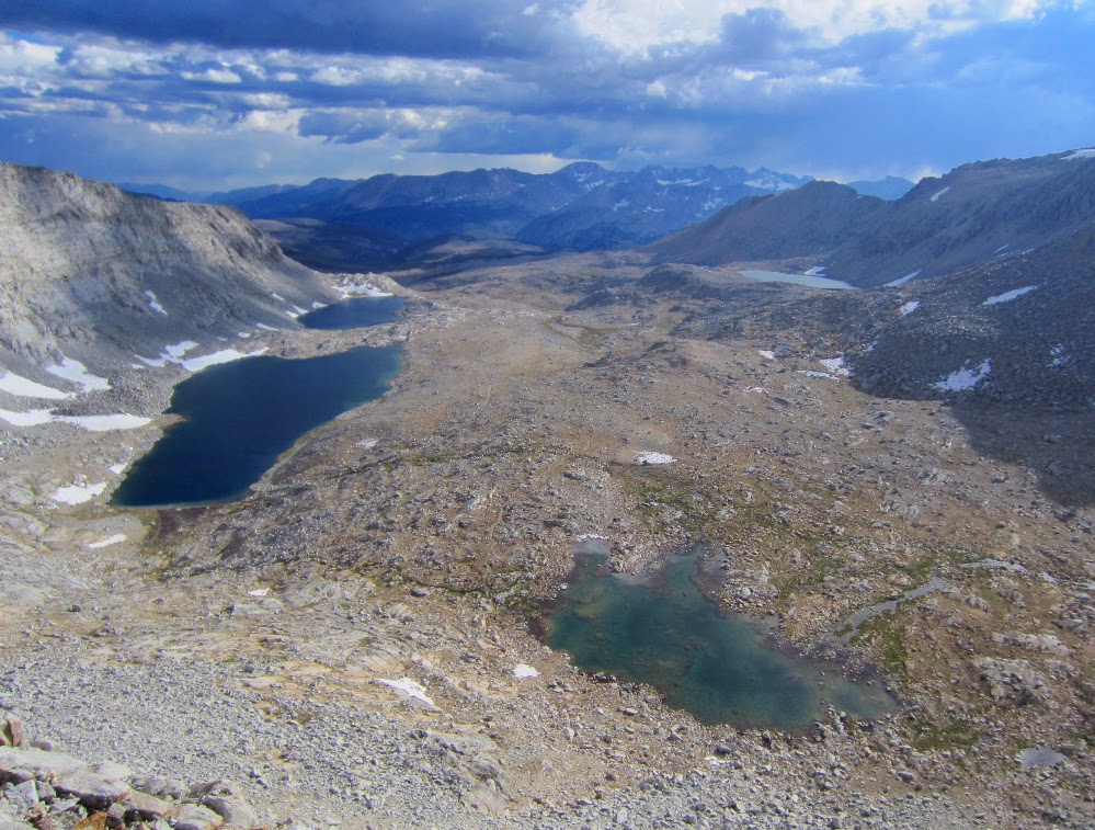
The trail through the huge flat area below the pass was another amazing plateau, a welcome change after climbing Forester.
Looking back at Forester Pass.
There are beautiful lakes just below Diamond Mesa where I had planned on camping, but I just kept going while feeling great at the end of the day.
I hiked well into the evening while looking for a spot to camp, but I just didn't want to stop. I knew if I stopped I would actually feel the soreness in my legs. I was ok if I just kept moving. Eventually I made it to a designated camp area (with bear boxes) by Tyndall Creek (just before the Shepherd Pass junction). I was hiking by headlamp and a nice couple helped me find a place to camp.
I setup camp and made dinner in the dark. It was a great day, having hiked over Glen Pass and Forester Pass. I slept like a baby.
In the morning the storm from yesterday was long gone and the view back toward Upper Basin and Mather Pass was crystal clear.
Upper Basin and Mather Pass from camp.
It was a clear morning and soon I was at the top of Pinchot Pass. The views to the north of Marjorie Lake were amazing. Like the views from many of the passes on the JMT, the vast scale of the area is hard to express or capture in photos.
Looking north from Pinchot Pass.
To the south of Pinchot Pass is a beautiful alpine area with meandering streams and wide open views of the red colored mountain peaks to the west. The view from below the pass of the gigantic southwest face of Mt. Wynne highlights the stripes of light colored granite. The trail is easy and I made good time to the Sawmill Pass trail junction.
The view of Mt. Wynne and Pinchot Pass (on the left) from the south side of Pinchot Pass.
The trail on the south side of Pinchot Pass.
The section of trail from Sawmill Pass to Woods Creek suspension bridge was probably my least favorite part of the JMT. It follows mainly granite stairs up and down along the creek for almost 4 miles. It may be that not eating enough was starting to tap my energy with some lagging at this point in the day. Sometimes I just didn't want to stop and eat, but by the time I reached the bridge I forced myself to stop for lunch. Feeling a little better I crossed the Woods Creek bridge. The suspension bridge was a big landmark for me. After reading so many trip reports about the bridge I was excited to see it in person.
Woods Creek Bridge.
I took a video while crossing the bridge. There are many camp sites on the opposite side, but as usual the entire area was vacant this late in the season. I saw one couple that looked like they were having a disagreement which made me extra stoked to be solo on the JMT. Just me and nature. Sweet!
Crossing the Woods Creek bridge.
The trail up to Rae Lakes from Woods Creek is steeper than I had anticipated and I just kept my slow and steady pace up the switchbacks and rocky trail. It started to rain lightly as I passed through some of the forested area. I passed a good large camp site littered with downed trees about half way up to the lakes. Later a small group would ask if there was a good camp for them nearby and I recommended the area.
Soon I reached the Dollar Lake and missed the classic photo opportunity of the lake with Fin Dome in the background. More time for photos later.
For the first time on the entire JMT I started to see large groups of people camping along the trail. At Arrowhead Lake there were a few groups of people wearing full rain gear taking photos along the lake. Full size free standing double wall tents, guys standing around in boots and warm jackets talking about the 'real world'. It all seemed so strange. I was warm as long as I kept moving along in shorts, t-shirt and trail runners. The light rain was keeping me at a nice comfortable temperature and I was hitting my late afternoon second wind. It felt like all of the less picturesque parts of the trail earlier in the day were a small price to pay to enjoy these late afternoons.
First view of Glen Pass under cloudy skies.
I could hear a group of people hanging out at the ranger station as I passed by but I just kept moving. After being on the trail solo for so long I wasn't anxious to break the mesmerizing feeling of being 'with' nature. The view of the first Rae Lake was beautiful and the storm clouds still hadn't produced much rain. I picked up the pace and started looking for good camp sites. I remember seeing a trip report where someone had camped right above the southern Rae Lake with good views of the Painted Lady. I just kept going and figured at worst I would find something just below Glen Pass.
Finally I reached the last Rae Lake and the views matched the pictures I had seen before. I hiked up a bluff up to a plateau and found several flat camp sites with great views of the lake and Painted Lady. After setting up camp I was a little startled by a man who came out of nowhere to say hi. He was camping nearby at the lakes outlet and was in the middle of a week long stay. After chatting for a while I made dinner (in the dark) and got to be early. The plan was to get up early and make it over Glenn Pass and Forester Pass to set up for the final stretch toward Whitney.
Camp on bluff overlooking Rae Lake and the Painted Lady.
I woke watching the colors of the sunrise slowly change from purple to bright red to orange. As I packed up the sun made its way down from the top of the surrounding peaks and lit up the Devils Crags across the canyon. The valley filled with light as I hiked up the Golden Staircase. What an unbelievable way to wake up!
Sunrise from camp overlooking Palisade Creek and Devils Crags.
Golden Staircase.
By the time I made it to Palisade Lake the sun was out and it was another beautiful morning. The lake is an amazing sub alpine body of crystal clear water. I could see to the bottom and there was still a large mass of ice deep inside the lake at the entry.
Palisade Lake
Palisade Lake
Palisade Lake
I was looking forward to Mather Pass and the hike up the granite canyon was a beautiful. The trail is almost invisible from below, but there is a well terraced set of switchbacks up to the pass. The view along the way is amazing. The size and scale of the place are HUGE. I could see coming back here and spending a week just exploring the lakes and peaks across the canyon.
I made it to the pass in good time, although by then I wasn't really paying too much attention to the actual time. Time was like something from the 'real world' that I didn't want to be reminded of. What an amazing escape from everything concrete. I felt alive.
View of Palisade Lake on the way to Mather Pass.
Palisade Peaks from the top of Mather Pass (12,100 feet).
I met a couple of guys on Mather Pass who were hiking a portion of the JMT and had met up earlier that week. One of them hiked in from Taboose Pass and the other from South Lake. There were kicking back and hiking at a leisurely pace back to exit via Taboose Pass. When I made some celebratory coffee using my Caldera Cone they came over and asked about ultralight gear etc. I think they were just into using a beer can as part of a stove. . . and it looked like beer was a large portion of their pack weight.
They commented on how strange it seemed to them that people get up at 6:00 am and hike all day. They preferred to fish and enjoy the wilderness in a different way. When I told them I was one of those guys who hikes most of the day so I could see as much as possible this time, they were cool. I think we all realized that everybody chooses to enjoy the wilderness in a different way, and that it's all equalized by the feeling and surroundings. How could anyone be disagreeable out here at the top of Mather Pass. I liked these guys.
I headed down the well graded but steep switchbacks down into Upper Basin. I love the feeling of being in the low flat alpine areas after doing so much ascent earlier in the morning. I slowly made my way back down into the forest and soon I was at the Taboose Pass/JMT junction.
View facing south from Mather Pass.
View facing south from Mather Pass. Upper Basin and Split Mountain.
View facing south from Mather Pass. Steep switchbacks on the way down.
Video from Mather Pass.
Moonscape along Upper Basin.
The afternoon clouds started to look ominous as I headed up the switchbacks toward the Bench Lake junction. By the time I met up with my buddies from Mather Pass it was starting to rain lightly. They decided to pick up the pace and get to Bench Lake for the night. I just kept on my steady pace toward Pinchot Pass. The plan was to camp just below Pinchot Pass, near Marjorie Lake, to get ready for the next morning. The rain was intermittent so I didn't bother getting out my jacket.
By the time I got within a half mile from Marjorie Lake the winds picked up and the storm really got going. Rain, hail and heavy winds suddenly hit hard. When I heard thunder I knew it was time to take some cover, but the terrain was limited to medium sized boulders and clumps of small trees/large shrubs.
I was in shorts, a t-shirt and running shoes and totally unprepared. There was no time to put on my rain jacket or pants when the lightning show began, and I was almost above timberline so I crouched under some shrubs and took cover. There was almost no time between the lightening and thunder. The sound of the thunder echoing against the huge granite walls was deafening and the hail was ridiculous.
I was pretty sure that I should do something to get to a better place, but I wasn't sure what that might be. Go out into the storm and run down an exposed ridge line to lower elevation? Stay put and risk getting hit by lightning? I put on my rain jacket and hunkered down.
After 30 minutes the storm passed and the flowers all exploded. The new snow and hail that had collected on the mountains was beautiful. The post rain fragrance was amazing. I made some dinner by this lake and slept like a baby under clear skies.