The popular "North Lake to South Lake Loop" or "Evolution Loop" is usually referred to as a "loop". . . The Forest Service and Recreation.gov describe it as the "North Lake to South Lake Loop". There are countless online trip reports for the "loop" including some on Summitpost, Backpackinglight and High Sierra Topix. I stopped counting after finding 14 videos for the "loop" on YouTube.
According to the FKT site the current fastest known time for the "Evolution Loop" is 10 hours and 31 minutes. Impressive, although not so much considering the FKT holder had to hitch a ride back to North Lake after "finishing" at South Lake.
I have often wondered what it would be like to do a proper loop and include the last section over the Tyee Plateau and close the circle back to North Lake . . . So last week I hiked from North Lake to North Lake and along the way threw in some cross country travel and peak bagging to keep it interesting. In the end it was a 64+ mile loop with four passes and 34,200' of elevation change.
I started with my usual late night drive through the desert on Wednesday night to camp at the base of the East Side of the Sierra near Independence. Spending a night at 4,000' always helps me acclimatize to the big climb over the Sierra Crest on the first day, and by Thursday morning I was ready for the climb over Lamarck Col from the North Lake trailhead.
This spring my hiking compadre Karl extended an invitation to join him on his annual early season hike on the PCT. I am used to snow in the High Sierra, and I usually bring snowshoes and serious winter gear. . . but Karl assured me that in the early spring we could go without the usual winter setup and hike on the snow with trail runners. I watched the forecast and snow level indicators online, and it looked like we lucked out and would be enjoying a rare week-long window of sunny skies and plenty of hard packed snow!
I woke up refreshed and after grabbing a Pro Bar for breakfast I was back on the trail passing through McClure Meadow and the rest of Evolution Valley. There are some steep switchbacks at the end of the valley that lead up to Evolution Lake and I was out of steam at the top, probably due to my meager breakfast. I took a break at an amazing spot overlooking the tarn just below Evolution Lake and watched deer drinking from the creek in the small valley below.
I met a colorful woman probably in her 70's who was clearly an experienced hiker, but still it seemed strange to see her alone way out in the wilderness. She slowed down enough to say something about having a nice day on 'the bench'. Maybe she was going to Darwin Bench just above us. Anyway, soon an older gentleman passed by and asked about her. He said they were hiking together and that she was definitely a very 'unique' person. These two were just some of the characters I would meet on the trail today.
Colby Meadow looking toward Evolution Basin.
Wow, the first look at Mt. Mendel, Mt. Darwin and Evolution Lake from the JMT.
The trail along Evolution Lake.
Evolution Lake on the way into Evolution Basin.
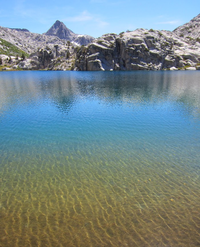
As I walked over a small crest Evolution Lake came into view. The contrast between the immense light granite of Mt. Mendel and the deep blue green water of Evolution Lake was amazing. The aqua color of the lake was indescribable. Just as I was walking along the lake a couple of runners passed by with only hydration packs, they seemed completely out of place. It was very strange to see these two cruising along so far out in the wilderness.
Evolution Lake (10,852 ft).
The hike up the Evolution Basin felt like walking on the moon, but with the most crystal clear creeks flowing into amazing lakes and tarns. I was struck by the azure color of Sapphire Lake and then finally Wanda Lake. I have never seen water with such a striking saturated blue color like Wanda Lake. This was becoming the best day on the trail by far.
Crossing Evolution Creek.
Sapphire Lake (10,966 ft) with Mt. Spencer and the side of Mt. Huxley.
Sapphire Lake
Evolution Basin.
Wanda Lake (11,426 ft).
Wanda Lake and the Goddard Divide. (Click for full size)
Muir Hut at the top of Muir Pass (11,955 ft.)
"The Range of Light"
Inside the Muir Hut.
Inside the Muir Hut.
Inside Muir Hut.
Finally at Muir Pass.
Heading south from Muir Pass. Helen Lake on the left. Black Giant (13,330 ft) on the right.
Helen Lake (11,617 ft).
After the final climb to Muir Pass I headed down toward Helen Lake, another crystal clear alpine lake. The lakes on either side of the pass are named after John Muir's daughters. I wished that I could just wander around this area for weeks, but I had to keep moving. On the way down the canyon I passed a large church youth group of 20 or more teens on their way up to the pass. First the bizarre solo woman, the strange ultra marathoners, then the large church group. What would be next?
The water flowing down the sides of the granite canyon walls was beautiful, I could hardly believe this place existed. "I must come back here" I thought to myself almost shouting it out loud, or maybe I did shout it. . . . there didn't seem to be much difference after a week solo in the wilderness.
I was losing light and just kept going as my late afternoon second wind kicked in. I finally found a flat campsite above a small tarn below Black Giant. I set up my bivy and quilt and slept under the stars after eating dinner at sunset.