Taboose Pass - Center Basin - Lake Marjorie - Bench Lake
With only a few more days of good weather before the first real winter storms hit I headed up Taboose Pass for a five day cross country solo trek. Taboose Pass is one of the four steep passes that provide relatively quick access over the Sierra Crest and directly into the High Sierra. The price for such convenient access are big climbs of around 6,000 feet in under 10 miles. In the summer a very early start is required to avoid the hot temperatures at lower elevations, but by starting in the fall the weather was enjoyable the entire way.
Once over Taboose Pass the plan was to cross three off-trail passes into some remote basins that have been on my radar for a few years. The fall colors were beautiful but unfortunately there was enough snow lingering on the north facing slopes that I had to avoid my cross country plans and stay in the relative safety of Center Basin, Lake Marjorie and Bench Lake.
After sleeping at a nearby trail camp I got an early start on Taboose Pass. The cool fall temperatures made for an enjoyable hike out of the desert elevations and up into the alpine regions near the top of the pass.
Route Map (click for full size)
Early morning on the 395 to Taboose Pass
Dirt road on the final few miles to Taboose Pass
Under 16 lbs with food and gear for five days.
Taboose Pass parking lot.
Taboose Pass trailhead.
Entering Inyo National Forest.
The first few miles of the trail cross the desert to the base of the mountains. . .
Desert terrain at the beginning of the Taboose Pass trail.
Starting the climb out of the desert.
The view back to the Owens Valley below.
Starting to gain some elevation after the first few miles.
After the first miles the trail climbs out of the desert and into a wooded area. The fall colors were beautiful in this short sections through the trees. . .
The first water crossing through the trees.
Fall colors.
Fall colors on the first wooded section of trail.
The clouds started to arrive by mid morning and would keep things cool for the rest of the hike. . .
Fall colors and storm clouds on the Taboose Pass trail.
The trail climbs a few head walls before reaching the alpine region. . .
Large waterfall at about 9,600 feet.
Several flat camp sites in this wooded area above the large waterfall.
Small flat camp site on the Taboose Pass trail.
After climbing through the final wooded section the trail finally reaches the alpine region and things start to look more like the High Sierra.
The final apline region of the Taboose Pass trail.
Short video from near the top of Taboose Pass.
Taboose Pass video.
The trail starts at 5,400 feet and it took about 7:15 to make it to the top at 11,352 feet. This includes a 45 minute nap and 15 minute lunch break along the way.
Finally at the top.
I made it in time for some spectacular sunset views of Arrow Peak, but there was a strong wind and I quickly made it to the cover of the forest and lower elevation for the night.
Sunset on Arrow Peak from near the top of Taboose Pass.
To avoid bears I made a simple stealth camp far away from any existing camp sites. By cooking and eating away from camp I have avoided any unwanted visits by bears in the backcountry.
Morning on my small stealth camp.
Day 2:
Instead of taking the trail all the way down to the river, then back up again I went cross country and followed the 10,600' contour until I reached the JMT in Upper Basin. At about 10,900' I left the trail again and headed northwest toward Upper Basin Crossing. The plan for the day was to climb this rarely used Class III pass as a shortcut to Amphitheater Lake. As I got closer I could see snow lingering on the north facing mountain slopes in the area so I decided to stay at lower elevation and save the cross country route for the summer.
The view Mt. Ickes, Arrow Peak, South Fork Kings River, Mt. Ruskin and Venacher Needle.
Fall colors in Upper Basin.
Snow near Frozen Lake Pass.
Snow in the north facing chute of Frozen Lake Pass
Lingering snow on Upper Basin Crossing.
Large un-named lake in Upper Basin with Split Mountain in the background.
Although the snow kept me off the cross country passes there were still plenty of beautiful places to explore nearby. I headed east toward the lakes below Split Mountain.
Easy cross country travel through Upper Basin to Split Mountain Lake.
Mt. Prater (left) and Split Mountain (right)
Tarp camp near the shore of Split Mountain Lake.
I found several places to camp and after setting up my tarp, quilt and pad I headed over to a small peninsula on the lake to make dinner and watch the alpenglow.
Making dinner on Split Mountain Lake.
A brief video of Split Mountain Lake:
Split Mountain video.
View from the peninsula on lake 11,592' aka Split Mountain Lake.
Alpenglow on Split Mountain.
It can get really cold during shoulder season in the High Sierra and it got COLD that night. The forecast was for the high 20's but it got down to 21 degrees. By wearing all of my clothes I stayed barely warm enough to sleep in my homemade 25 degree quilt.
Cold shoulder season camp under Split Mountain.
Day 3:
The next morning I decided to explore the many lakes and granite benches on the east side of Upper Basin on the way back to the JMT. I ended up discovering several beautiful lakes, meadows and waterfalls with no sign of human influence, even though the busy JMT was less than a half mile away! I'm grateful the JMT corridor keeps most people on the trail while leaving these nearby gems mostly untouched.
Once back on trail there would be plenty of time to climb Pinchot Pass and camp below Mt. Wynne. I remember this area from my thru-hike of the JMT in 2011. There is an amazing mixture of red and black colored metamorphic rock, light colored granite, green meadows and crystal clear streams just below the south side of Pinchot Pass. . . and the alpenglow on the jagged west slope of Mt. Wynne would be incredible.
Easy cross country along granite benches just above the JMT in Upper Basin.
Another rarely visited lake just off the JMT in Upper Basin.
Fall in Upper Basin.
The JMT just above the South Fork Kings River in Upper Basin.
By early afternoon I reached Lake Marjorie and I stopped for a lunch break on the grassy shoreline.
Looking back toward Upper Basin on the way to Lake Marjorie.
Grassy shoreline of Lake Marjorie.
The grassy shoreline of Lake Marjorie was a perfect spot for a break. The sun was warm and the skies were perfectly blue. I relaxed on the manicured lawn for a quick nap but after a short time I noticed the sun was beginning to be blocked by some passing clouds.
By the time I started up the JMT toward Pinchot Pass some clouds started to appear from the north. Once I reached the final switchbacks at 11,600' dark storm clouds had completely covered the sky. I could hardly believe that within one hour the weather had changed from bluebird skies to black storm clouds everywhere. I didn't want to get stuck on the pass when the lightning started and I wasn't sure if this was the beginning of a major snow storm.
I had some basic snow gear including micro-spikes, gaiters and waterproof socks but it is always possible for a storm to quickly drop several inches of snow and I did not want to get stuck at high altitude for days waiting out the first winter storm. I kept thinking about Larry Conn who got stuck at the top of Taboose Pass when a winter storm hit in October 2012. The storm lasted a few days and his remains weren't discovered until the spring snow melt the following year.
I decided to head back down to lower elevation just to be safe.
Storm clouds suddenly approaching from the north.
Dark storm clouds filling the sky!
Short video of storms approaching Pinchot Pass:
Pinchot Pass storms.
Sheltering from the storm.
After a few hours of rumbling the clouds finally started to clear, but by then it was 4:30 pm and with only an hour of daylight left I made dinner and watched the sunset on the Palisades in the distance.
After the storm below Pinchot Pass.
Sunset on the Palisades.
Dinner with a view.
Day 4:
With the possibility of another storm I decided to head back one day early and explore Bench Lake on the way back to Taboose Pass. There are so many beautiful places to see along this section of the JMT I found myself making several stops along the way.
The anti-selfie.
Golden meadow.
Mt. Rusking from an un-named lake along the JMT.
A few straggling fish.
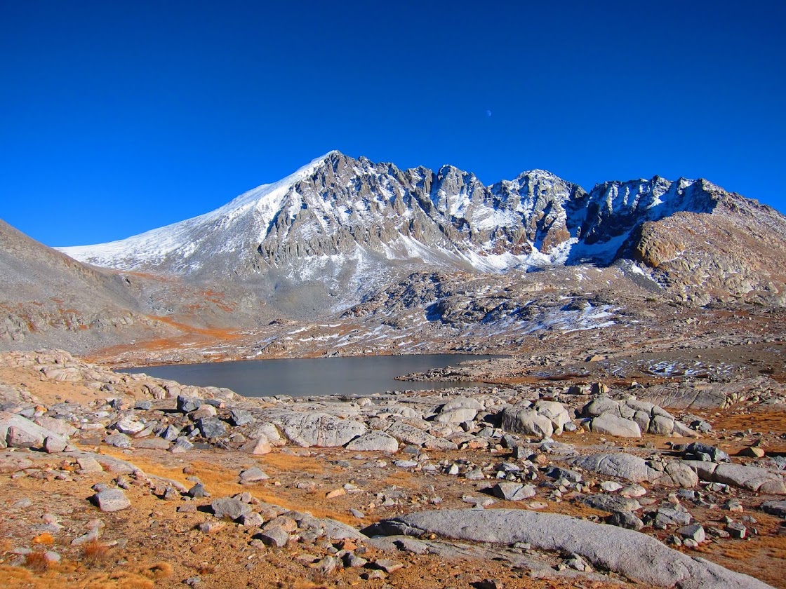
Bench Lake and Arrow Peak.
West side approach to Taboose Pass.
Last look at Arrow Peak from Taboose Pass.
Taboose Pass (11,352')
The climb back down Taboose Pass was like hiking a completely different trail. Aside from the easier mostly downhill climb the red rocks on the side of the canyon were highlighted by the long shadows and afternoon sun.
Starting back down Taboose Pass.
Moonscape on upper Taboose Pass trail.
Rocky trail.
The walls above Taboose Creek.
Red rock fans above Taboose Creek
Red rock fans above Taboose Creek
Red rock spires above Taboose Creek.
Red rock spires above the Taboose Pass trail.
Winding rocky switchbacks on the Taboose Pass trail.
Goodale Mountain from the Taboose Pass trail.
The lower wooded section of trail was a nice change from the rocky switchbacks above. The creek flows through the trail in may places here.
Small waterfall along the Taboose Pass trail.
Fall on the Taboose Pass trail.
Fall colors on the last crossing of Taboose Creek.
Somehow the timing of the climb back to the trailhead was just right for a great sunset view. . . but it got dark quickly and I hiked by headlamp in the dark for the last 30 minutes.
It was a perfect end to a solo shoulder season journey over Taboose Pass.
Almost there, sunset on the way down the Taboose Pass trail.
Some thoughts on gear:
My experiment with the combination of a 1/8" Gossamer Gear foam insulation pad and a Kookabay Torsolight inflatable pad just wasn't enough for the cold temperatures on this trip. For the past year I have been using a Therm-a-rest Xlite inflatable pad for most three season trips and a heavier Xtherm in the winter. For shorter summer trips when I can sleep on the sand a Gossamer Gear nightlight foam torso pad has been fine. I was hoping to save some weight on this trip by trying a combination of small foam insulation pad and very small inflatable pad. . . but I will be going back to my trusty Xlite for most trips for a while.
The journey for the lightest most functional backpacking kit continues. For details about some of the homemade gear I used on this trip check out:
Im very Jealous right now! I did a trip in August out of Mosquito flats and along the JMT and the smoke was getting bad, so I had intended to get back out in Sept-Oct and let it slide...ahhhh Anyway, I have to say I enjoy your trip and gear reports. I have a question about Taboose Pass. Ive heard the trail is so rocky as to maybe not go with trail runners., so Im wondering what your experience was . Thanks
It was a tough summer for smoke this year. I have turned back due to smoke in the past and it can get really thick during a fire. Sorry to hear your planned trip was cut short.
I prefer trail runners in the Sierra and local mountains even on extended 10 day trips with a starting pack weight of up to 27 lbs. I never carry heavier weights but I would recommend a traditional hiking boot when carrying a pack weight over 30 lbs.
For some perspective I weigh 195 lbs and was comfortable hiking 16-20 miles per day for two weeks on the JMT in Montrail trail runners.
I also used Montrail trail runners on the Sierra High Route, and much of that route is on difficult cross country boulder fields.
Last summer I switched to Altra Olympus trail runners. They have an amazing amount of padding (36mm) and were comfortable on the Taboose Pass trip.
Everyone is different and I realize it all comes down to personal preference.
Hey Andy, I'm with you on the trail runners. However, I've heard that this particular hike has some pretty chunky cobblestones on the way up Taboose Pass. I take it that you didn't have any ankle-bruising issues on this hike?
Hey Brian. I was a little concerned about the rocky trail before heading out on this hike. Fortunately it was fine with trail runners. The rockiest section is near the top. Even though it's rocky the trail has been used for so long it was stable with no ankle-twisting worries. Have fun!
Hi Andy, Another incredible photo essay gift from my favorite country! Love your blog,.....I was curious if you could tell me the dimensions of how you spaced the tie outs on your 6 X 9 zpacks tarp? Would it still be your top pic for a trip like Caboose?...Hope to order one soon. Thank You!
Nice photos. I have seen Split Mountain from the JMT and more recently from the east side from the pond below Red Lake. It is a beautiful mountain. The latter view is the better for me anyway. It's a tough climb to Taboose Pass. I got to the pass and it was all clouded over and beginning to rain. I went back down to the single campsite you show and spent the night. I hiked down the next day.


Im very Jealous right now! I did a trip in August out of Mosquito flats and along the JMT and the smoke was getting bad, so I had intended to get back out in Sept-Oct and let it slide...ahhhh
ReplyDeleteAnyway, I have to say I enjoy your trip and gear reports. I have a question about Taboose Pass. Ive heard
the trail is so rocky as to maybe not go with trail runners., so Im wondering what your experience was .
Thanks
It was a tough summer for smoke this year. I have turned back due to smoke in the past and it can get really thick during a fire. Sorry to hear your planned trip was cut short.
DeleteI prefer trail runners in the Sierra and local mountains even on extended 10 day trips with a starting pack weight of up to 27 lbs. I never carry heavier weights but I would recommend a traditional hiking boot when carrying a pack weight over 30 lbs.
For some perspective I weigh 195 lbs and was comfortable hiking 16-20 miles per day for two weeks on the JMT in Montrail trail runners.
I also used Montrail trail runners on the Sierra High Route, and much of that route is on difficult cross country boulder fields.
Last summer I switched to Altra Olympus trail runners. They have an amazing amount of padding (36mm) and were comfortable on the Taboose Pass trip.
Everyone is different and I realize it all comes down to personal preference.
Have fun!
Andy.
Hey Andy, I'm with you on the trail runners. However, I've heard that this particular hike has some pretty chunky cobblestones on the way up Taboose Pass. I take it that you didn't have any ankle-bruising issues on this hike?
DeleteHey Brian. I was a little concerned about the rocky trail before heading out on this hike. Fortunately it was fine with trail runners. The rockiest section is near the top. Even though it's rocky the trail has been used for so long it was stable with no ankle-twisting worries. Have fun!
DeleteHi Andy, Another incredible photo essay gift from my favorite country! Love your blog,.....I was curious if you could tell me the dimensions of how you spaced the tie outs on your 6 X 9 zpacks tarp? Would it still be your top pic for a trip like Caboose?...Hope to order one soon. Thank You!
ReplyDeleteHey Timber Line! I got your email about the 6' x 9' tarp. Did you end up getting one? See you out there, Andy.
ReplyDeleteNice photos. I have seen Split Mountain from the JMT and more recently from the east side from the pond below Red Lake. It is a beautiful mountain. The latter view is the better for me anyway. It's a tough climb to Taboose Pass. I got to the pass and it was all clouded over and beginning to rain. I went back down to the single campsite you show and spent the night. I hiked down the next day.
ReplyDeleteThanks Dale. Taboose Pass and Upper Basin are among some of my favorite areas of the Sierra.
Delete