BBT 2017 ~ Santa Monica Backbone Trail

Big views on the BBT. 

The Santa Monica Backbone Trail ~ 2017


The Santa Monica Backbone Trail follows the crest of the Santa Monica Mountains for 68 miles from Point Mugu to Will Rogers State Park. The BBT (Backbone Trail) climbs 19,000 feet (and descends 18,500 feet) over a collection of dirt trails, gravel roads and even some rock scrambling. 

During the spring of 2017 my hiking compadre Hobbes and I set out to thru-hike the entire route in under 3 days. The heat on the steep climbs was grueling, sometimes well into the 90's, with no natural water sources, exposed trails and little shade. . . but the miles of wildflowers and epic views made every step worth while.  

Let the adventure begin.


~ Aerial Overview of the BBT ~


Aerial overview of the Santa Monica Backbone Trail

North Lake to North Lake Loop ~ 2017

Sunrise below Muir Pass. 

The popular "North Lake to South Lake Loop" or "Evolution Loop" is usually referred to as a "loop". . . The Forest Service and Recreation.gov describe it as the "North Lake to South Lake Loop". There are countless online trip reports for the "loop" including some on Summitpost, Backpackinglight and High Sierra Topix. I stopped counting after finding 14 videos for the "loop" on YouTube.

According to the FKT site the current fastest known time for the "Evolution Loop" is 10 hours and 31 minutes. Impressive, although not so much considering the FKT holder had to hitch a ride back to North Lake after "finishing" at South Lake.

I have often wondered what it would be like to do a proper loop and include the last section over the Tyee Plateau and close the circle back to North Lake  . . . So last week I hiked from North Lake to North Lake and along the way threw in some cross country travel and peak bagging to keep it interesting. In the end it was a 64+ mile loop with four passes and 34,200' of elevation change.

I started with my usual late night drive through the desert on Wednesday night to camp at the base of the East Side of the Sierra near Independence. Spending a night at 4,000' always helps me acclimatize to the big climb over the Sierra Crest on the first day, and by Thursday morning I was ready for the climb over Lamarck Col from the North Lake trailhead.


North Lake to North Lake Loop, 64 miles. 

Mt. Whitney to Mt. Langley Traverse~ September 2016

The summit of Mt. Whitney 14,500'.
In the spirit of Alastair Humphrey's Microadventure I took off for a quick late season adventure into the High Sierra last weekend. In an effort to fit as much adventure into a 'micro' amount of time I decided to climb the two nearest 14'ers in the Southern Sierra and hike the distance between each one via a 30 mile cross country route along the way.

To make this a mini-thru hike I left a car at Horseshoe Meadows at the southern end of the route and took a shuttle to Whitney Portal in the north where I would begin. Although the route was only 30 miles the total elevation change was over 23,000 feet via mostly cross country terrain with a few class III climbs to keep things interesting.

Once the shuttle dropped me off at Whitney Portal the only way back to the car was to commit to the route. . . and I began to wonder if my plan was too adventurous for just one weekend.

Mt. Whitney & Mt. Langley Microadventure route.

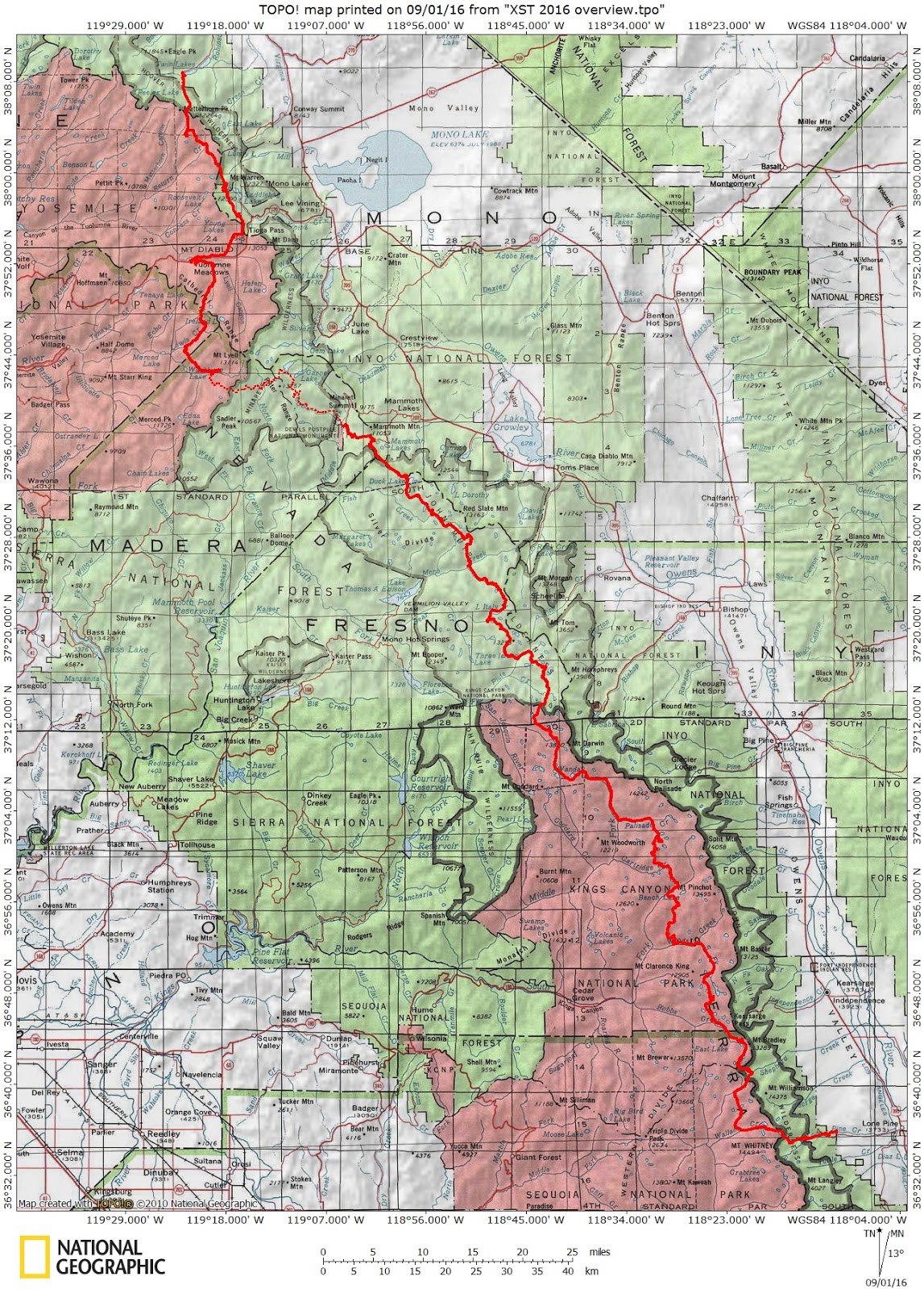
XST 2016 ~ Cross Country Sierra Traverse

Mt. Ansel Adams along the XST - Cross Country Sierra Traverse

This year the mountain gods provided a tremendous opportunity. . . a three week window during the prime summer season to explore the High Sierra. Through a series of unplanned circumstances my usual one week trip morphed into a three week epic adventure! After pouring over maps and considering many possible routes I finally settled on a cross country traverse of the High Sierra. . . I stitched together portions of the Sierra High RouteSouth Sierra High RouteKings Canyon High Basin Route along with some of my favorite cross country alternatives to create a cross country traverse of the High Sierra. 

In the end I climbed 25 High Sierra Passes over 257 miles in 22 days. I started preparing for the trip in January and followed Alan Dixon's training program which included long weekend hikes up to 30 miles per day leading up to the start in July. Some of the climbs and long days were more challenging than I anticipated and the fields of wild flowers at the beginning almost derailed the whole trip. Although I planned on climbing 31 passes over 295 miles I had to skip the sections from the Lyell Fork to Mammoth and Ionian Basin due to allergies. Fortunately I was able to re-energize during a zero day and get back into the wilderness to finish the route. 

Many thanks to the endless support from my wife Candy. I missed you! 


~ XST 2016 ~ 


Cross Country Sierra Traverse: 25 Passes over 257 miles.


XST 2016 ~ Cross Country Sierra Traverse

XSL 2015 ~ Cross Country SEKI Loop ~ Days 1-4

Morning in Kaweah Basin

XSL 2015 ~ Cross Country SEKI Loop ~ 

Nine days of Cross Country travel in Sequoia & Kings Canyon National Park

~ Overview Map ~

Click for full size map.

In the spirit of Amy Lauterbach's Big Seki Loop and Mike White's Circle of Solitude I decided to create my own loop through the Sequoia & Kings Canyon area. . . but I wanted to stay off existing trails and use cross country routes as much as possible. At times bad weather chased me down to lower elevation but in the end I crossed 7 High Sierra passes over 81 miles.

Days 1-4: Tablelands to Cloud Canyon

After planning all winter I was excited to get into the backcountry. . . but the forecast was for thunderstorms during the first four days! I figured it couldn't be all that bad so I headed into the unknown. I had rain gear, a double wall ultralight tent and even a new custom backpack. I was ready for the worst possible conditions, and at least I could get closer to the high passes than I would if I just stayed home. It seemed like a logical decision at the time. . . 

XSL 2015 ~ Cross Country SEKI Loop ~ Day 5

The outlet of Colby Lake.

~ Day 5: Colby Pass to Kaweah Basin ~

Starting early in the cirque below Colby Lake I kept a fast pace almost all the way to Colby Pass. The wildflowers along the outlet creek from Colby Lake were beautiful. I took a break at an amazing camp site right above the shore of the lake (mental note: great camp for next time). The altitude, heat and humidity finally slowed me down at the base of the long boulderfield but I made it to the top by mid morning. The trailwork on the way to the top is impressive, much like the switchbacks on Mt. Whitney.


Creek below Colby Lake. 

XSL 2015 ~ Cross Country SEKI Loop ~ Day 6


Morning in Kaweah Basin

~ Day 6: Kaweah Basin ~

This was a beautiful clear day and I spent hours exploring Kaweah Basin and the neighboring Picket Creek Basin. So much classic Sierra scenery in one day!


Awesome view of the Kaweah Peaks from Island Lake in Kaweah Basin.

XSL 2015 ~ Cross Country SEKI Loop ~ Day 7


Cyrstal clear water in Kaweah Basin

~ Day 7: Pyra Queen Col  ~


Lisa, Michael and I got an early start and headed to Pyra Queen Col, one of the few passes that provide access into or out of Kaweah Basin. Pyra Queen Col is a Class II cross country pass and involves steep and loose boulder and scree fields which make for slow going at times. . . but the views are worth the effort.

Michael, Andy & Lisa


Andy & Lisa in Kaweah Basin


Starting the climb to Pyra Queen Col


XSL 2015 ~ Cross Country SEKI Loop ~ Days 8 & 9

Looking across Nine Lakes Basin toward Kaweah Gap

                                             ~ Days 8 & 9: High Sierra Trail ~

Days 8 and 9 were spent exploring some of the High Sierra Trail with a side trip to Tamarack Lake. After many years in the High Sierra I was looking forward to finally seeing Precipice Lake and Hamilton Lake, two of the beautiful lakes along the High Sierra Trail. The scenery didn't disappoint and after some bushwhacking I made camp in the dark along the shore of Tamarack Lake. 


Spring on the Pacific Crest Trail ~ June 2016


Snow dudes. 

This spring my hiking compadre Karl extended an invitation to join him on his annual early season hike on the PCT. I am used to snow in the High Sierra, and I usually bring snowshoes and serious winter gear. . . but Karl assured me that in the early spring we could go without the usual winter setup and hike on the snow with trail runners. I watched the forecast and snow level indicators online, and it looked like we lucked out and would be enjoying a rare week-long window of sunny skies and plenty of hard packed snow!

Bishop Pass ~ March 2016

Mt. Agassiz from the outlet of Long Lake.


Bishop Pass ~ March 2016


After reading a recent article about weekend warriors called The Ultimate 64 Hour Weekend I decided to create my own quick weekend adventure. To make the most of the weekend I left home right after work on Friday, drove all night to Bishop then slept under the stars in the Buttermilk area.

The next morning I sped up South Lake Road until the snow was too deep to drive and parked by the Tyee Lakes trailhead. Following a 3 mile road-walk to the Bishop Pass trailhead I snowshoed over uneven ground on a partially covered trail up to about 10,100'.

From there it was all cross country with the trail usually buried under a few feet of snow. For the rest of the weekend I had the entire wilderness to myself with no sign of tracks from cross country skiers or other snowshoers.

Evolution ~ February 2016


Evolution ~ February 2016


Lamarck Col - Darwin Canyon - Darwin Bench - Evolution Basin

Every winter I get cabin fever. I start to dream about routes for the next summer and relive past adventures while pouring over photos and videos. After a while I find myself wanting to get into the backcountry but waiting months until next summer is just too long. 

So a few years ago I started embracing the fourth season. After a few seasons a small group of my backpacking buddies started to join the winter crew and before long we had a annual snowshoeing trip. 

But last year I struggled to keep up after barely getting over a nasty cold right before the trip. I watched from behind as everyone else strolled up the 2,000 foot climb the first day. I was the slow guy that my friends politely waited for. I was sure they were really thinking something like, "no problem dude, we'll take yet another break so this sorry slow screwball can catch his breath". 

So this year I resolved not to let the gluttonous trifecta of Thanksgiving - Christmas - New Years get the best of me. I spent hours on the local coastal trails building my cardio base. After countless lunges, squats, crunches and overnights at altitude in the local mountains I felt ready to conquer the High Sierra again.

This trip was supposed to be a training hike for the annual snowshoe trip this spring, but when a long weekend opened up suddenly Alpine Mike from the popular online group High Sierra Topix was able to join me. 

Winter Sierra Gear List ~ 2016

In a recent post on Backpackinglight someone asked if it was possible to stay safe, warm, dry and well fed in the winter while keeping an Ultralight base weight (10 lbs or less). 

Fortunately the answer is yes! 

Check out my latest gear list from a recent 4 day snowshoeing trip. I stayed warm and even over-slept down to 10 F using the gear below. 

Let the gram gods rejoice.


Taboose Pass ~ October 2015

Sunset on Arrow Peak from Taboose Pass.

Taboose Pass ~ October 2015


Taboose Pass - Center Basin - Lake Marjorie - Bench Lake

With only a few more days of good weather before the first real winter storms hit I headed up Taboose Pass for a five day cross country solo trek. Taboose Pass is one of the four steep passes that provide relatively quick access over the Sierra Crest and directly into the High Sierra. The price for such convenient access are big climbs of around 6,000 feet in under 10 miles. In the summer a very early start is required to avoid the hot temperatures at lower elevations, but by starting in the fall the weather was enjoyable the entire way. 

Once over Taboose Pass the plan was to cross three off-trail passes into some remote basins that have been on my radar for a few years. The fall colors were beautiful but unfortunately there was enough snow lingering on the north facing slopes that I had to avoid my cross country plans and stay in the relative safety of Center Basin, Lake Marjorie and Bench Lake. 

Shoulder Season Gear List - 2015

Let the Gram Gods rejoice! The latest gear list has finally arrived for all of us gearheads out there interested in keeping our packs lightweight while having some fun in the backcountry during the colder shoulder season. Only use lightweight gear if you have the experience and skills necessary to stay safe, warm and well fed in the backcountry:


Horseshoe Meadows Loop - September 2015


Sly Blue Lake in Miter Basin.

Horseshoe Meadows Loop 2015


Cottonwood Pass - Guyout Pass - Crabtree Pass - New Army Pass


I always keep backpack ready just in case the opportunity arises to get away for a weekend in the High Sierra . . . so when the mountain gods provided an opening last weekend I grabbed my gear and headed for the backcountry. 

It wasn't long before I found myself reciting the necessary regulations to the ranger, "six to eight inches, durable surfaces, bear canister, one hundred feet, carry out all trash". There was no need to speak in complete sentences, he knew that I knew the deal. The ranger hardly looked up while handing me a permit for the Cottonwood Pass trail out of Horseshoe Meadows. 

I left the Cottonwood Pass trailhead at 1:00 pm on Friday and followed the familiar sandy trail toward the pass at 11,140 feet. After a few hours I joined the Pacific Crest Trail and headed north toward Crabtree Meadow. 

Just before the Chicken Spring Lake I was surprised to meet a few PCT hikers. They were going southbound from Canada to Mexico and appeared to be well seasoned hikers. As we chatted one of them commented, "that's a small pack your carrying". I was traveling with one of my smallest homemade packs as part of a minimalist setup; only 12 pounds with gear, food and fuel for three days. 

We talked for a while but I didn't linger too long, I wanted to make the 20 miles to Crabtree Meadow before dark. . .

3 Season San Gorgonio Gear List ~ 2015

For a recent trip on the Forsee Loop trail in the San Gorgonio Mountains I used a comfortable but lightweight gear setup. Since this was only an overnight trip I brought a few luxury items like a full size (extra large) Therm-a-rest X-lite inflatable sleeping pad, warm puffy down anorak style jacket and a full size camera. . . all while still keeping a base weight of 6.5 lbs. So if you are interested in making your trip a little easier next time I hope some of the ideas in this gear list will help. See you on the trail! 

Miter Basin and Mt. Langley ~ October 2014

Falls colors in Miter Basin
There is something special about fall in the High Sierra. The days are shorter and the weather is much colder but the crowds are long gone and the colors are beautiful. Over a long weekend and over 30 miles in the backcountry I saw only four other hikers.  

After spending the night at the trailhead the night before I got an early start on the Cottonwood Lakes trail. I slept in a homemade sleeping bag, but it was only rated to 40 degrees. It was below 40 that night! 

Fortunately I brought warmer gear for the hike in. 

Mt. Brewer Loop ~ October 2014

Kings Canyon

Earlier this summer I planned on traversing the Great Western Divide during a ten day solo trip through the Sierra, but when bad weather approached I had to cut it short. This time I rejoined the Great Western Divide near Lake Reflection for a four day trip over three cross country passes, three remote basins and an attempt at climbing Mt. Brewer.

The plan was to finish the north end of the Great Western Divide during a 40 mile loop out of Roads End in Kings Canyon. Although the total mileage didn't pose a problem the daily climbs were a challenge. The daily elevation change on trail ranged from the 5,000 foot ascent on the first day to the 6,980 foot descent on the hike out. Ouch.

Great Western Divide ~ July 2014

.
Sunrise on the Kaweah Peaks
.

Great Western Divide ~ July 2014

Kaweah Basin - Milestone Basin - Thunder Basin

~ Overview Map ~

(Click for full size map)